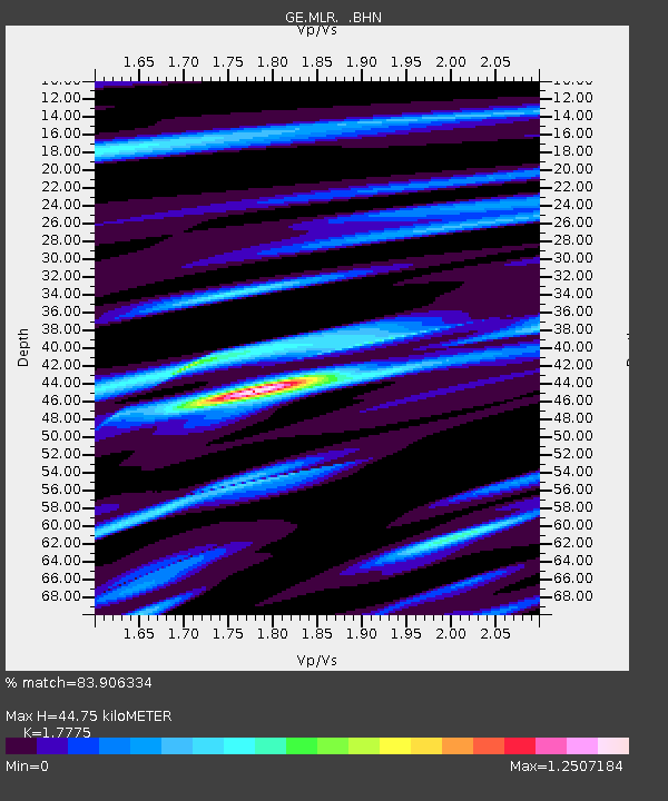
MLR GEOFON Station Muntele Rosu, Romania - Earthquake Result Viewer

Earthquake location: Off East Coast Of Honshu, Japan
Earthquake latitude/longitude: 40.8/143.4
Earthquake time(UTC): 1995/12/30 (364) 12:11:07 GMT
Earthquake Depth: 33 km
Earthquake Magnitude: 5.7 MB, 6.2 MS, 6.4 UNKNOWN, 6.3 MW
Earthquake Catalog/Contributor: WHDF/NEIC
Network: GE GEOFON
Station: MLR GEOFON Station Muntele Rosu, Romania
Lat/Lon: 45.49 N/25.95 E
Elevation: 1378 m
Distance: 77.5 deg
Az: 320.249 deg
Baz: 43.649 deg
Ray Param: 0.05023526
Estimated Moho Depth: 44.75 km
Estimated Crust Vp/Vs: 1.78
Assumed Crust Vp: 6.194 km/s
Estimated Crust Vs: 3.485 km/s
Estimated Crust Poisson's Ratio: 0.27
Radial Match: 83.906334 %
Radial Bump: 400
Transverse Match: 73.66856 %
Transverse Bump: 400
SOD ConfigId: 6273
Insert Time: 2010-03-09 06:24:27.870 +0000
GWidth: 2.5
Max Bumps: 400
Tol: 0.001

Signal To Noise

ChannelStoNSTALTA
GE:MLR: :BHN:19951230T12:22:28.636023Z1.61703194.2383985E-72.6210975E-7
GE:MLR: :BHE:19951230T12:22:28.636023Z1.85661724.328453E-72.3313653E-7
GE:MLR: :BHZ:19951230T12:22:28.636023Z6.5932561.4971794E-62.270774E-7
Arrivals
Ps5.8 SECOND
PpPs20 SECOND
PsPs/PpSs25 SECOND