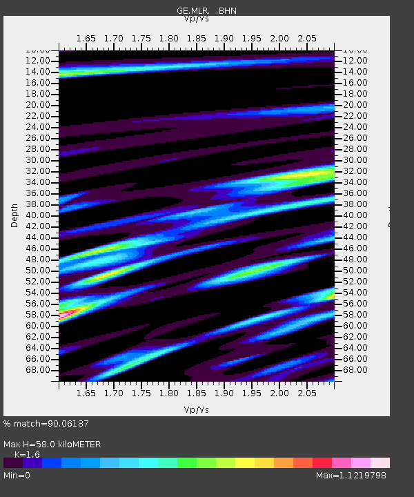
MLR GEOFON Station Muntele Rosu, Romania - Earthquake Result Viewer

Earthquake location: Off East Coast Of Kamchatka
Earthquake latitude/longitude: 51.7/159.8
Earthquake time(UTC): 1996/06/30 (182) 11:32:35 GMT
Earthquake Depth: 33 km
Earthquake Magnitude: 5.5 MB, 5.9 MS, 6.1 UNKNOWN, 6.0 MW
Earthquake Catalog/Contributor: WHDF/NEIC
Network: GE GEOFON
Station: MLR GEOFON Station Muntele Rosu, Romania
Lat/Lon: 45.49 N/25.95 E
Elevation: 1378 m
Distance: 75.3 deg
Az: 328.383 deg
Baz: 27.617 deg
Ray Param: 0.051699616
Estimated Moho Depth: 58.0 km
Estimated Crust Vp/Vs: 1.60
Assumed Crust Vp: 6.194 km/s
Estimated Crust Vs: 3.871 km/s
Estimated Crust Poisson's Ratio: 0.18
Radial Match: 90.06187 %
Radial Bump: 400
Transverse Match: 89.25047 %
Transverse Bump: 400
SOD ConfigId: 6273
Insert Time: 2010-03-09 06:24:34.315 +0000
GWidth: 2.5
Max Bumps: 400
Tol: 0.001

Signal To Noise

ChannelStoNSTALTA
GE:MLR: :BHN:19960630T11:43:44.716016Z6.301122.1347948E-73.3879612E-8
GE:MLR: :BHE:19960630T11:43:44.716016Z4.14767651.170812E-72.822814E-8
GE:MLR: :BHZ:19960630T11:43:44.716016Z12.8497637.0725775E-75.5040527E-8
Arrivals
Ps5.8 SECOND
PpPs24 SECOND
PsPs/PpSs29 SECOND