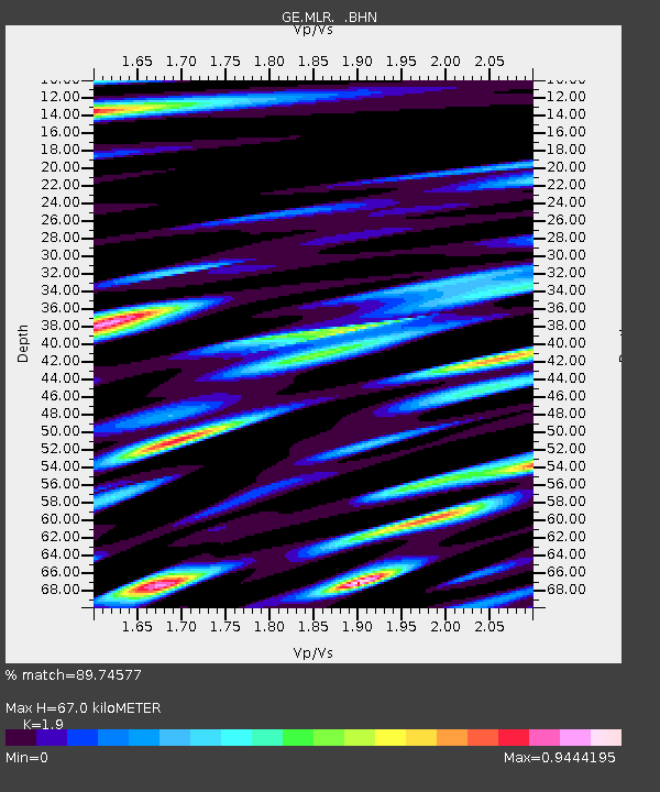
MLR GEOFON Station Muntele Rosu, Romania - Earthquake Result Viewer

Earthquake location: Andreanof Islands, Aleutian Is.
Earthquake latitude/longitude: 51.5/-178.1
Earthquake time(UTC): 1996/06/08 (160) 23:19:15 GMT
Earthquake Depth: 33 km
Earthquake Magnitude: 5.9 MB, 6.3 MS, 6.5 UNKNOWN, 6.1 MS
Earthquake Catalog/Contributor: WHDF/NEIC
Network: GE GEOFON
Station: MLR GEOFON Station Muntele Rosu, Romania
Lat/Lon: 45.49 N/25.95 E
Elevation: 1378 m
Distance: 81.2 deg
Az: 343.121 deg
Baz: 14.956 deg
Ray Param: 0.047718275
Estimated Moho Depth: 67.0 km
Estimated Crust Vp/Vs: 1.90
Assumed Crust Vp: 6.194 km/s
Estimated Crust Vs: 3.26 km/s
Estimated Crust Poisson's Ratio: 0.31
Radial Match: 89.74577 %
Radial Bump: 400
Transverse Match: 83.63523 %
Transverse Bump: 400
SOD ConfigId: 6273
Insert Time: 2010-03-09 06:24:40.569 +0000
GWidth: 2.5
Max Bumps: 400
Tol: 0.001

Signal To Noise

ChannelStoNSTALTA
GE:MLR: :BHN:19960608T23:30:56.365015Z9.9778164.445369E-74.4552525E-8
GE:MLR: :BHE:19960608T23:30:56.365015Z3.13028171.281101E-74.092606E-8
GE:MLR: :BHZ:19960608T23:30:56.365015Z23.1806221.1964352E-65.161359E-8
Arrivals
Ps10.0 SECOND
PpPs31 SECOND
PsPs/PpSs41 SECOND