You are here: Home > Network List > GE - GEOFON Stations List
> Station MLR GEOFON Station Muntele Rosu, Romania > Earthquake Result Viewer
MLR GEOFON Station Muntele Rosu, Romania - Earthquake Result Viewer
| Earthquake location: |
Southern Xinjiang, China |
| Earthquake latitude/longitude: |
40.0/76.7 |
| Earthquake time(UTC): |
1996/03/19 (079) 15:00:26 GMT |
| Earthquake Depth: |
28 km |
| Earthquake Magnitude: |
5.7 MB, 6.0 MS, 6.3 UNKNOWN, 6.1 MW |
| Earthquake Catalog/Contributor: |
WHDF/NEIC |
|
| Network: |
GE GEOFON |
| Station: |
MLR GEOFON Station Muntele Rosu, Romania |
| Lat/Lon: |
45.49 N/25.95 E |
| Elevation: |
1378 m |
|
| Distance: |
37.2 deg |
| Az: |
295.614 deg |
| Baz: |
80.009 deg |
| Ray Param: |
0.076238796 |
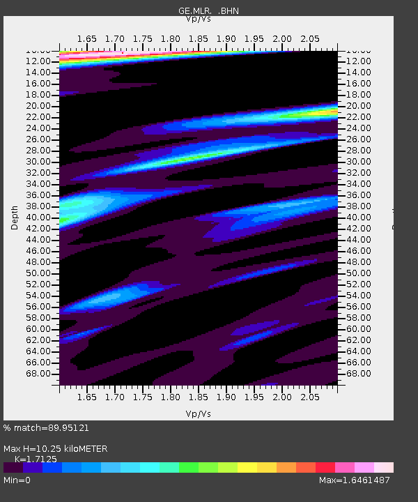
| Estimated Moho Depth: |
10.25 km |
| Estimated Crust Vp/Vs: |
1.71 |
| Assumed Crust Vp: |
6.194 km/s |
| Estimated Crust Vs: |
3.617 km/s |
| Estimated Crust Poisson's Ratio: |
0.24 |
|
| Radial Match: |
89.95121 % |
| Radial Bump: |
400 |
| Transverse Match: |
79.443596 % |
| Transverse Bump: |
400 |
| SOD ConfigId: |
6273 |
| Insert Time: |
2010-03-09 06:24:44.546 +0000 |
| GWidth: |
2.5 |
| Max Bumps: |
400 |
| Tol: |
0.001 |
|

Signal To Noise
| Channel | StoN | STA | LTA |
| GE:MLR: :BHN:19960319T15:07:03.898987Z | 1.1650363 | 1.1067625E-7 | 9.499811E-8 |
| GE:MLR: :BHE:19960319T15:07:03.898987Z | 2.152697 | 2.7327627E-7 | 1.2694599E-7 |
| GE:MLR: :BHZ:19960319T15:07:03.898987Z | 8.171025 | 6.2724536E-7 | 7.676459E-8 |
| Arrivals |
| Ps | 1.3 SECOND |
| PpPs | 4.2 SECOND |
| PsPs/PpSs | 5.4 SECOND |


