You are here: Home > Network List > TA - USArray Transportable Network (new EarthScope stations) Stations List
> Station TOLK Toolik Lake Research Station, AK, USA > Earthquake Result Viewer
TOLK Toolik Lake Research Station, AK, USA - Earthquake Result Viewer
*The percent match for this event was below the threshold and hence no stack was calculated.
| Earthquake location: |
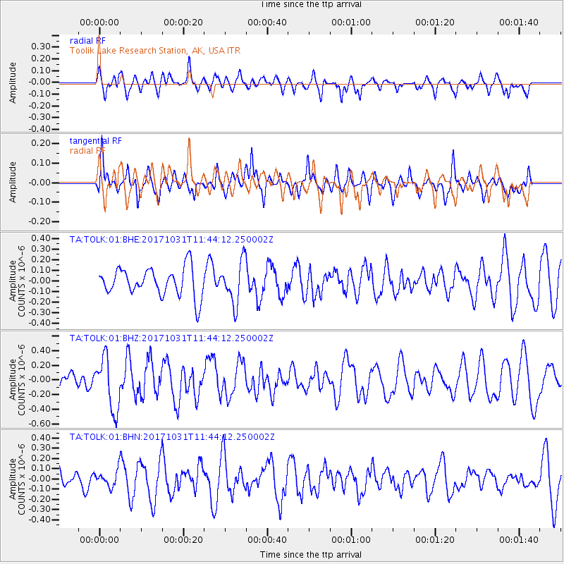
Seram, Indonesia |
| Earthquake latitude/longitude: |
-3.8/127.7 |
| Earthquake time(UTC): |
2017/10/31 (304) 11:31:42 GMT |
| Earthquake Depth: |
27 km |
| Earthquake Magnitude: |
5.9 Mww |
| Earthquake Catalog/Contributor: |
NEIC PDE/us |
|
| Network: |
TA USArray Transportable Network (new EarthScope stations) |
| Station: |
TOLK Toolik Lake Research Station, AK, USA |
| Lat/Lon: |
68.64 N/149.57 W |
| Elevation: |
760 m |
|
| Distance: |
90.8 deg |
| Az: |
21.31 deg |
| Baz: |
261.837 deg |
| Ray Param: |
$rayparam |
*The percent match for this event was below the threshold and hence was not used in the summary stack. |
|
| Radial Match: |
51.070576 % |
| Radial Bump: |
376 |
| Transverse Match: |
45.871128 % |
| Transverse Bump: |
328 |
| SOD ConfigId: |
2429771 |
| Insert Time: |
2017-11-14 11:33:48.405 +0000 |
| GWidth: |
2.5 |
| Max Bumps: |
400 |
| Tol: |
0.001 |
|
Signal To Noise
| Channel | StoN | STA | LTA |
| TA:TOLK:01:BHZ:20171031T11:44:12.250002Z | 2.555754 | 3.642896E-7 | 1.4253705E-7 |
| TA:TOLK:01:BHN:20171031T11:44:12.250002Z | 0.4782066 | 8.172936E-8 | 1.7090805E-7 |
| TA:TOLK:01:BHE:20171031T11:44:12.250002Z | 1.5335745 | 2.0294738E-7 | 1.3233618E-7 |
| Arrivals |
| Ps | |
| PpPs | |
| PsPs/PpSs | |


