You are here: Home > Network List > GE - GEOFON Stations List
> Station MLR GEOFON Station Muntele Rosu, Romania > Earthquake Result Viewer
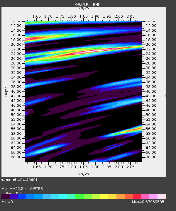
MLR GEOFON Station Muntele Rosu, Romania - Earthquake Result Viewer
| Earthquake location: |
Mindanao, Philippines |
| Earthquake latitude/longitude: |
9.4/126.5 |
| Earthquake time(UTC): |
1996/09/20 (264) 12:24:42 GMT |
| Earthquake Depth: |
33 km |
| Earthquake Magnitude: |
5.4 MB, 6.0 MS, 6.3 UNKNOWN, 6.0 MW |
| Earthquake Catalog/Contributor: |
WHDF/NEIC |
|
| Network: |
GE GEOFON |
| Station: |
MLR GEOFON Station Muntele Rosu, Romania |
| Lat/Lon: |
45.49 N/25.95 E |
| Elevation: |
1378 m |
|
| Distance: |
90.7 deg |
| Az: |
316.254 deg |
| Baz: |
75.896 deg |
| Ray Param: |
0.041652624 |
| Estimated Moho Depth: |
22.5 km |
| Estimated Crust Vp/Vs: |
1.89 |
| Assumed Crust Vp: |
6.194 km/s |
| Estimated Crust Vs: |
3.269 km/s |
| Estimated Crust Poisson's Ratio: |
0.31 |
|
| Radial Match: |
84.48491 % |
| Radial Bump: |
400 |
| Transverse Match: |
82.09005 % |
| Transverse Bump: |
400 |
| SOD ConfigId: |
6273 |
| Insert Time: |
2010-03-09 06:24:54.920 +0000 |
| GWidth: |
2.5 |
| Max Bumps: |
400 |
| Tol: |
0.001 |
|

Signal To Noise
| Channel | StoN | STA | LTA |
| GE:MLR: :BHN:19960920T12:37:10.102014Z | 1.6294746 | 1.0592112E-7 | 6.5003235E-8 |
| GE:MLR: :BHE:19960920T12:37:10.102014Z | 1.171674 | 9.933411E-8 | 8.477965E-8 |
| GE:MLR: :BHZ:19960920T12:37:10.102014Z | 2.057355 | 1.6392583E-7 | 7.967796E-8 |
| Arrivals |
| Ps | 3.3 SECOND |
| PpPs | 10 SECOND |
| PsPs/PpSs | 14 SECOND |


