You are here: Home > Network List > GE - GEOFON Stations List
> Station MLR GEOFON Station Muntele Rosu, Romania > Earthquake Result Viewer
MLR GEOFON Station Muntele Rosu, Romania - Earthquake Result Viewer
| Earthquake location: |
Myanmar |
| Earthquake latitude/longitude: |
19.3/95.0 |
| Earthquake time(UTC): |
1996/11/11 (316) 09:22:27 GMT |
| Earthquake Depth: |
80 km |
| Earthquake Magnitude: |
5.6 MB, 5.4 MS, 6.0 UNKNOWN, 5.9 MW |
| Earthquake Catalog/Contributor: |
WHDF/NEIC |
|
| Network: |
GE GEOFON |
| Station: |
MLR GEOFON Station Muntele Rosu, Romania |
| Lat/Lon: |
45.49 N/25.95 E |
| Elevation: |
1378 m |
|
| Distance: |
61.9 deg |
| Az: |
311.854 deg |
| Baz: |
90.543 deg |
| Ray Param: |
0.060377065 |
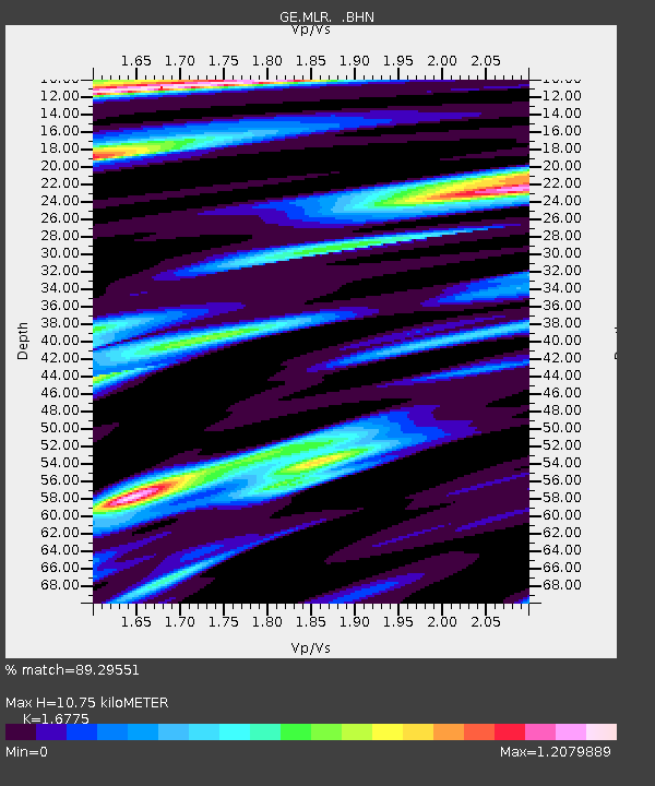
| Estimated Moho Depth: |
10.75 km |
| Estimated Crust Vp/Vs: |
1.68 |
| Assumed Crust Vp: |
6.194 km/s |
| Estimated Crust Vs: |
3.693 km/s |
| Estimated Crust Poisson's Ratio: |
0.22 |
|
| Radial Match: |
89.29551 % |
| Radial Bump: |
400 |
| Transverse Match: |
89.229294 % |
| Transverse Bump: |
400 |
| SOD ConfigId: |
6273 |
| Insert Time: |
2010-03-09 06:24:57.539 +0000 |
| GWidth: |
2.5 |
| Max Bumps: |
400 |
| Tol: |
0.001 |
|

Signal To Noise
| Channel | StoN | STA | LTA |
| GE:MLR: :BHN:19961111T09:32:08.041003Z | 2.0696719 | 3.4485385E-8 | 1.6662248E-8 |
| GE:MLR: :BHE:19961111T09:32:08.041003Z | 2.8941426 | 4.251311E-8 | 1.4689363E-8 |
| GE:MLR: :BHZ:19961111T09:32:08.041003Z | 10.932842 | 1.2668943E-7 | 1.1587968E-8 |
| Arrivals |
| Ps | 1.2 SECOND |
| PpPs | 4.4 SECOND |
| PsPs/PpSs | 5.7 SECOND |


