You are here: Home > Network List > GE - GEOFON Stations List
> Station MLR GEOFON Station Muntele Rosu, Romania > Earthquake Result Viewer
MLR GEOFON Station Muntele Rosu, Romania - Earthquake Result Viewer
| Earthquake location: |
Eastern Kashmir |
| Earthquake latitude/longitude: |
35.3/78.1 |
| Earthquake time(UTC): |
1996/11/19 (324) 10:44:46 GMT |
| Earthquake Depth: |
33 km |
| Earthquake Magnitude: |
6.1 MB, 7.1 MS, 6.9 UNKNOWN, 6.8 MW |
| Earthquake Catalog/Contributor: |
WHDF/NEIC |
|
| Network: |
GE GEOFON |
| Station: |
MLR GEOFON Station Muntele Rosu, Romania |
| Lat/Lon: |
45.49 N/25.95 E |
| Elevation: |
1378 m |
|
| Distance: |
40.4 deg |
| Az: |
300.91 deg |
| Baz: |
85.674 deg |
| Ray Param: |
0.07437985 |
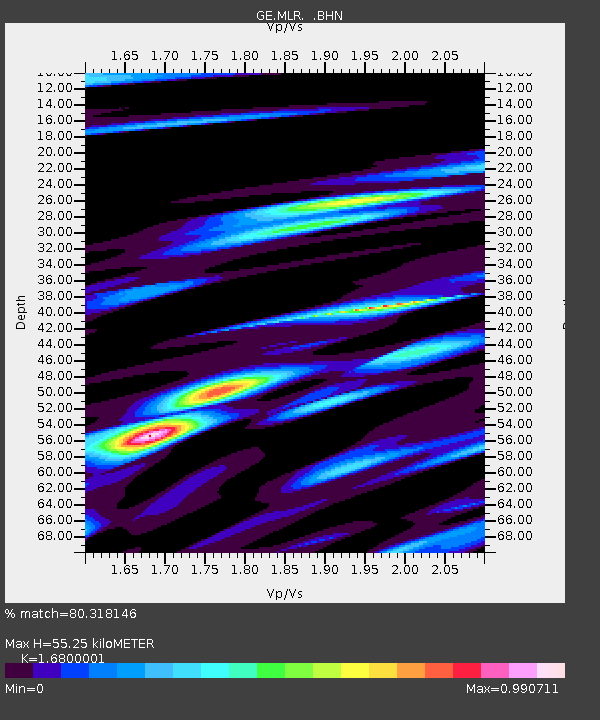
| Estimated Moho Depth: |
55.25 km |
| Estimated Crust Vp/Vs: |
1.68 |
| Assumed Crust Vp: |
6.194 km/s |
| Estimated Crust Vs: |
3.687 km/s |
| Estimated Crust Poisson's Ratio: |
0.23 |
|
| Radial Match: |
80.318146 % |
| Radial Bump: |
400 |
| Transverse Match: |
85.03913 % |
| Transverse Bump: |
400 |
| SOD ConfigId: |
6273 |
| Insert Time: |
2010-03-09 06:24:58.933 +0000 |
| GWidth: |
2.5 |
| Max Bumps: |
400 |
| Tol: |
0.001 |
|

Signal To Noise
| Channel | StoN | STA | LTA |
| GE:MLR: :BHN:19961119T10:51:50.19101Z | 0.9171793 | 2.238109E-8 | 2.440209E-8 |
| GE:MLR: :BHE:19961119T10:51:50.19101Z | 1.4958594 | 3.5018303E-8 | 2.3410156E-8 |
| GE:MLR: :BHZ:19961119T10:51:50.19101Z | 6.571992 | 1.078708E-7 | 1.6413715E-8 |
| Arrivals |
| Ps | 6.5 SECOND |
| PpPs | 22 SECOND |
| PsPs/PpSs | 29 SECOND |


