You are here: Home > Network List > GE - GEOFON Stations List
> Station MLR GEOFON Station Muntele Rosu, Romania > Earthquake Result Viewer
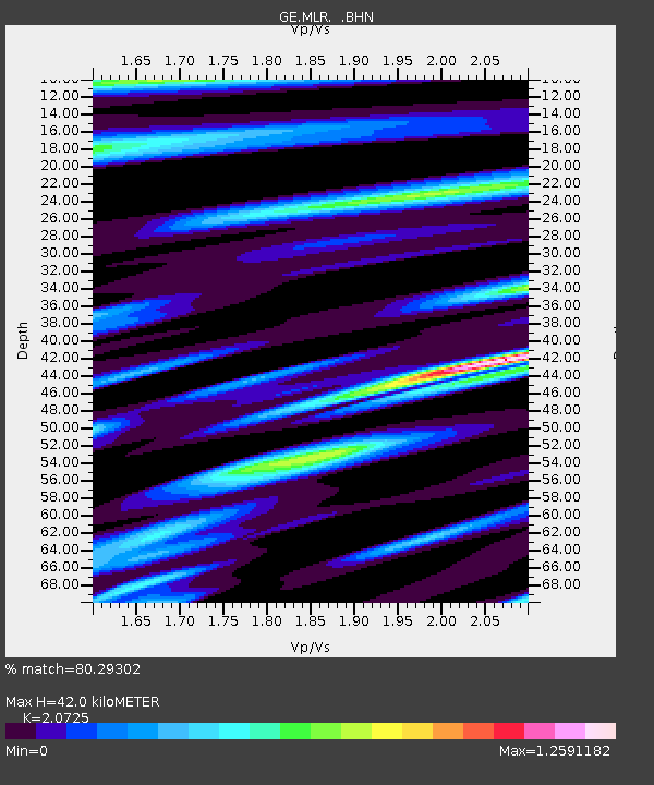
MLR GEOFON Station Muntele Rosu, Romania - Earthquake Result Viewer
| Earthquake location: |
Mindanao, Philippines |
| Earthquake latitude/longitude: |
9.8/125.8 |
| Earthquake time(UTC): |
1997/10/06 (279) 12:30:05 GMT |
| Earthquake Depth: |
106 km |
| Earthquake Magnitude: |
5.9 MB, 6.5 UNKNOWN, 6.4 MW |
| Earthquake Catalog/Contributor: |
WHDF/NEIC |
|
| Network: |
GE GEOFON |
| Station: |
MLR GEOFON Station Muntele Rosu, Romania |
| Lat/Lon: |
45.49 N/25.95 E |
| Elevation: |
1378 m |
|
| Distance: |
89.9 deg |
| Az: |
316.126 deg |
| Baz: |
76.203 deg |
| Ray Param: |
0.041690495 |
| Estimated Moho Depth: |
42.0 km |
| Estimated Crust Vp/Vs: |
2.07 |
| Assumed Crust Vp: |
6.194 km/s |
| Estimated Crust Vs: |
2.989 km/s |
| Estimated Crust Poisson's Ratio: |
0.35 |
|
| Radial Match: |
80.29302 % |
| Radial Bump: |
400 |
| Transverse Match: |
61.480286 % |
| Transverse Bump: |
400 |
| SOD ConfigId: |
6273 |
| Insert Time: |
2010-03-09 06:25:09.400 +0000 |
| GWidth: |
2.5 |
| Max Bumps: |
400 |
| Tol: |
0.001 |
|

Signal To Noise
| Channel | StoN | STA | LTA |
| GE:MLR: :BHN:19971006T12:42:21.753003Z | 0.6065252 | 1.3399499E-7 | 2.2092237E-7 |
| GE:MLR: :BHE:19971006T12:42:21.753003Z | 2.153623 | 3.6802237E-7 | 1.7088522E-7 |
| GE:MLR: :BHZ:19971006T12:42:21.753003Z | 6.8618283 | 9.870791E-7 | 1.4385074E-7 |
| Arrivals |
| Ps | 7.4 SECOND |
| PpPs | 20 SECOND |
| PsPs/PpSs | 28 SECOND |


