You are here: Home > Network List > GE - GEOFON Stations List
> Station MLR GEOFON Station Muntele Rosu, Romania > Earthquake Result Viewer
MLR GEOFON Station Muntele Rosu, Romania - Earthquake Result Viewer
| Earthquake location: |
Hokkaido, Japan Region |
| Earthquake latitude/longitude: |
43.8/145.0 |
| Earthquake time(UTC): |
1997/11/15 (319) 07:05:16 GMT |
| Earthquake Depth: |
161 km |
| Earthquake Magnitude: |
5.8 MB, 6.1 UNKNOWN, 6.1 MW |
| Earthquake Catalog/Contributor: |
WHDF/NEIC |
|
| Network: |
GE GEOFON |
| Station: |
MLR GEOFON Station Muntele Rosu, Romania |
| Lat/Lon: |
45.49 N/25.95 E |
| Elevation: |
1378 m |
|
| Distance: |
75.9 deg |
| Az: |
320.672 deg |
| Baz: |
40.711 deg |
| Ray Param: |
0.050922178 |
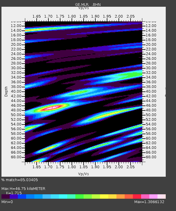
| Estimated Moho Depth: |
46.75 km |
| Estimated Crust Vp/Vs: |
1.72 |
| Assumed Crust Vp: |
6.194 km/s |
| Estimated Crust Vs: |
3.612 km/s |
| Estimated Crust Poisson's Ratio: |
0.24 |
|
| Radial Match: |
85.03405 % |
| Radial Bump: |
400 |
| Transverse Match: |
76.743645 % |
| Transverse Bump: |
400 |
| SOD ConfigId: |
6273 |
| Insert Time: |
2010-03-09 06:25:14.178 +0000 |
| GWidth: |
2.5 |
| Max Bumps: |
400 |
| Tol: |
0.001 |
|

Signal To Noise
| Channel | StoN | STA | LTA |
| GE:MLR: :BHN:19971115T07:16:14.628015Z | 5.147692 | 5.5199695E-7 | 1.0723193E-7 |
| GE:MLR: :BHE:19971115T07:16:14.628015Z | 3.0631 | 2.7824117E-7 | 9.083646E-8 |
| GE:MLR: :BHZ:19971115T07:16:14.628015Z | 23.420986 | 1.4440758E-6 | 6.165734E-8 |
| Arrivals |
| Ps | 5.6 SECOND |
| PpPs | 20 SECOND |
| PsPs/PpSs | 25 SECOND |


