You are here: Home > Network List > CI - Caltech Regional Seismic Network Stations List
> Station MPM Manuel Prospect Mine, California, USA > Earthquake Result Viewer
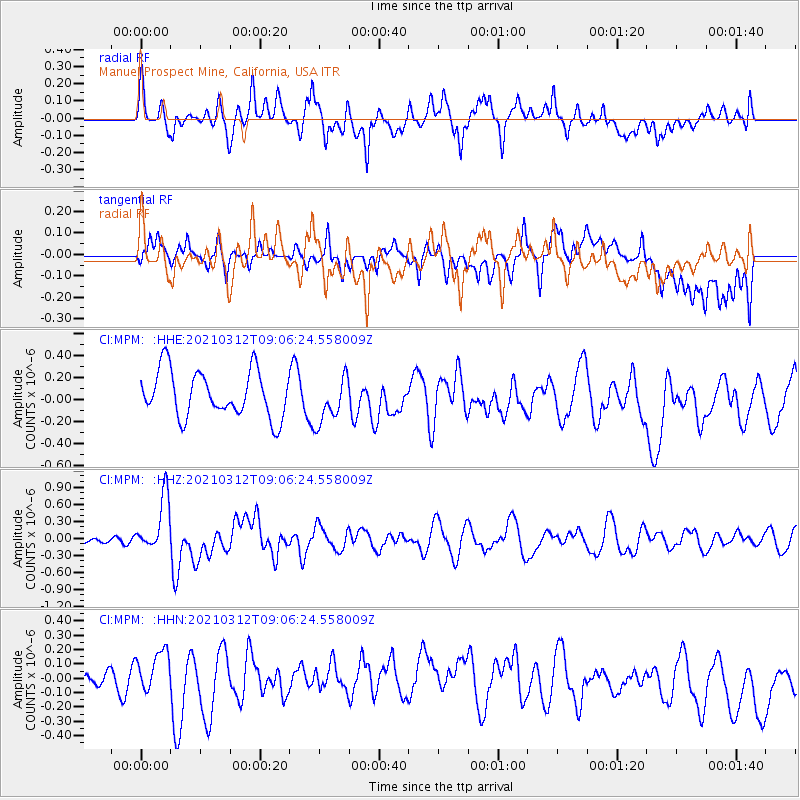
MPM Manuel Prospect Mine, California, USA - Earthquake Result Viewer
*The percent match for this event was below the threshold and hence no stack was calculated.
| Earthquake location: |
Southeast Of Loyalty Islands |
| Earthquake latitude/longitude: |
-22.4/174.4 |
| Earthquake time(UTC): |
2021/03/12 (071) 08:54:12 GMT |
| Earthquake Depth: |
10 km |
| Earthquake Magnitude: |
5.9 Mww |
| Earthquake Catalog/Contributor: |
NEIC PDE/us |
|
| Network: |
CI Caltech Regional Seismic Network |
| Station: |
MPM Manuel Prospect Mine, California, USA |
| Lat/Lon: |
36.06 N/117.49 W |
| Elevation: |
185 m |
|
| Distance: |
86.7 deg |
| Az: |
48.859 deg |
| Baz: |
239.33 deg |
| Ray Param: |
$rayparam |
*The percent match for this event was below the threshold and hence was not used in the summary stack. |
|
| Radial Match: |
60.358574 % |
| Radial Bump: |
400 |
| Transverse Match: |
42.637012 % |
| Transverse Bump: |
400 |
| SOD ConfigId: |
24334971 |
| Insert Time: |
2021-03-26 09:02:48.377 +0000 |
| GWidth: |
2.5 |
| Max Bumps: |
400 |
| Tol: |
0.001 |
|
Signal To Noise
| Channel | StoN | STA | LTA |
| CI:MPM: :HHZ:20210312T09:06:24.558009Z | 5.3222384 | 4.8887557E-7 | 9.185525E-8 |
| CI:MPM: :HHN:20210312T09:06:24.558009Z | 1.4882543 | 1.6962973E-7 | 1.13979E-7 |
| CI:MPM: :HHE:20210312T09:06:24.558009Z | 1.0208832 | 2.1371021E-7 | 2.0933855E-7 |
| Arrivals |
| Ps | |
| PpPs | |
| PsPs/PpSs | |


