You are here: Home > Network List > GE - GEOFON Stations List
> Station MLR GEOFON Station Muntele Rosu, Romania > Earthquake Result Viewer
MLR GEOFON Station Muntele Rosu, Romania - Earthquake Result Viewer
| Earthquake location: |
Mindanao, Philippines |
| Earthquake latitude/longitude: |
8.1/123.7 |
| Earthquake time(UTC): |
1998/05/23 (143) 17:44:47 GMT |
| Earthquake Depth: |
658 km |
| Earthquake Magnitude: |
5.9 MB, 6.1 UNKNOWN, 6.0 MW |
| Earthquake Catalog/Contributor: |
WHDF/NEIC |
|
| Network: |
GE GEOFON |
| Station: |
MLR GEOFON Station Muntele Rosu, Romania |
| Lat/Lon: |
45.49 N/25.95 E |
| Elevation: |
1378 m |
|
| Distance: |
89.7 deg |
| Az: |
315.818 deg |
| Baz: |
78.803 deg |
| Ray Param: |
0.041479416 |
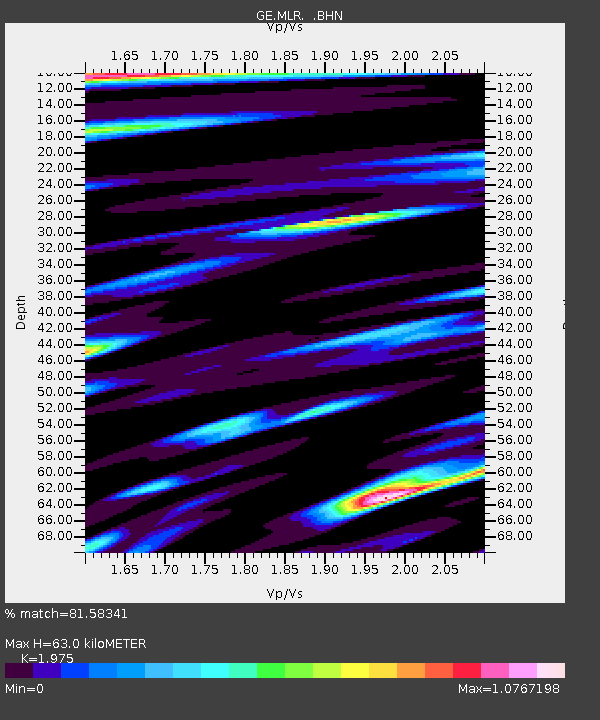
| Estimated Moho Depth: |
63.0 km |
| Estimated Crust Vp/Vs: |
1.98 |
| Assumed Crust Vp: |
6.194 km/s |
| Estimated Crust Vs: |
3.136 km/s |
| Estimated Crust Poisson's Ratio: |
0.33 |
|
| Radial Match: |
81.58341 % |
| Radial Bump: |
400 |
| Transverse Match: |
70.85816 % |
| Transverse Bump: |
400 |
| SOD ConfigId: |
4480 |
| Insert Time: |
2010-03-09 06:25:18.575 +0000 |
| GWidth: |
2.5 |
| Max Bumps: |
400 |
| Tol: |
0.001 |
|

Signal To Noise
| Channel | StoN | STA | LTA |
| GE:MLR: :BHN:19980523T17:56:06.478015Z | 31.950508 | 1.292598E-6 | 4.0456257E-8 |
| GE:MLR: :BHE:19980523T17:56:06.478015Z | 2.2462249 | 3.441326E-7 | 1.5320488E-7 |
| GE:MLR: :BHZ:19980523T17:56:06.478015Z | 4.0675507 | 2.3183016E-7 | 5.6995027E-8 |
| Arrivals |
| Ps | 10 SECOND |
| PpPs | 30 SECOND |
| PsPs/PpSs | 40 SECOND |


