You are here: Home > Network List > GE - GEOFON Stations List
> Station MLR GEOFON Station Muntele Rosu, Romania > Earthquake Result Viewer
MLR GEOFON Station Muntele Rosu, Romania - Earthquake Result Viewer
| Earthquake location: |
Off East Coast Of Kamchatka |
| Earthquake latitude/longitude: |
52.2/159.5 |
| Earthquake time(UTC): |
1998/05/27 (147) 20:41:37 GMT |
| Earthquake Depth: |
60 km |
| Earthquake Magnitude: |
5.5 MB, 6.0 UNKNOWN, 5.9 MW |
| Earthquake Catalog/Contributor: |
WHDF/NEIC |
|
| Network: |
GE GEOFON |
| Station: |
MLR GEOFON Station Muntele Rosu, Romania |
| Lat/Lon: |
45.49 N/25.95 E |
| Elevation: |
1378 m |
|
| Distance: |
74.8 deg |
| Az: |
328.126 deg |
| Baz: |
27.492 deg |
| Ray Param: |
0.051973015 |
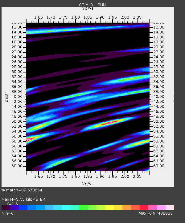
| Estimated Moho Depth: |
57.5 km |
| Estimated Crust Vp/Vs: |
1.60 |
| Assumed Crust Vp: |
6.194 km/s |
| Estimated Crust Vs: |
3.871 km/s |
| Estimated Crust Poisson's Ratio: |
0.18 |
|
| Radial Match: |
89.573654 % |
| Radial Bump: |
400 |
| Transverse Match: |
85.53525 % |
| Transverse Bump: |
400 |
| SOD ConfigId: |
4480 |
| Insert Time: |
2010-03-09 06:25:19.861 +0000 |
| GWidth: |
2.5 |
| Max Bumps: |
400 |
| Tol: |
0.001 |
|

Signal To Noise
| Channel | StoN | STA | LTA |
| GE:MLR: :BHN:19980527T20:52:40.777014Z | 22.832174 | 9.812785E-7 | 4.2977884E-8 |
| GE:MLR: :BHE:19980527T20:52:40.777014Z | 11.4109535 | 3.616629E-7 | 3.169436E-8 |
| GE:MLR: :BHZ:19980527T20:52:40.777014Z | 6.490158 | 2.0734585E-7 | 3.1947735E-8 |
| Arrivals |
| Ps | 5.8 SECOND |
| PpPs | 23 SECOND |
| PsPs/PpSs | 29 SECOND |


