You are here: Home > Network List > TA - USArray Transportable Network (new EarthScope stations) Stations List
> Station O17K Koliganek, Bristol Bay, AK, USA > Earthquake Result Viewer
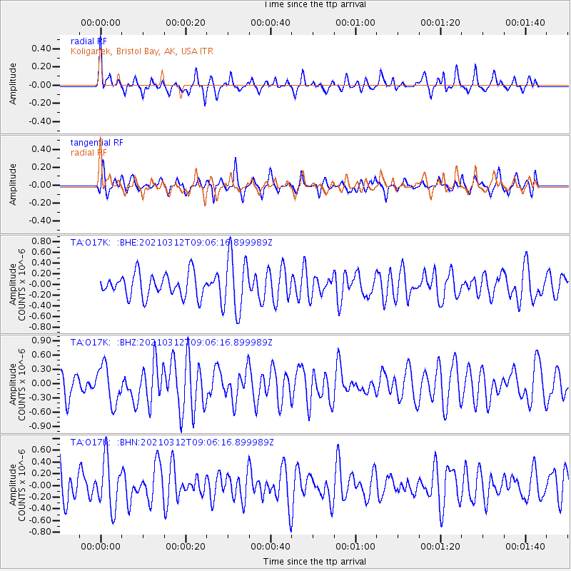
O17K Koliganek, Bristol Bay, AK, USA - Earthquake Result Viewer
*The percent match for this event was below the threshold and hence no stack was calculated.
| Earthquake location: |
Southeast Of Loyalty Islands |
| Earthquake latitude/longitude: |
-22.4/174.4 |
| Earthquake time(UTC): |
2021/03/12 (071) 08:54:12 GMT |
| Earthquake Depth: |
10 km |
| Earthquake Magnitude: |
5.9 Mww |
| Earthquake Catalog/Contributor: |
NEIC PDE/us |
|
| Network: |
TA USArray Transportable Network (new EarthScope stations) |
| Station: |
O17K Koliganek, Bristol Bay, AK, USA |
| Lat/Lon: |
59.77 N/157.09 W |
| Elevation: |
156 m |
|
| Distance: |
85.1 deg |
| Az: |
14.02 deg |
| Baz: |
206.305 deg |
| Ray Param: |
$rayparam |
*The percent match for this event was below the threshold and hence was not used in the summary stack. |
|
| Radial Match: |
57.04133 % |
| Radial Bump: |
350 |
| Transverse Match: |
58.03475 % |
| Transverse Bump: |
400 |
| SOD ConfigId: |
24334971 |
| Insert Time: |
2021-03-26 09:08:15.949 +0000 |
| GWidth: |
2.5 |
| Max Bumps: |
400 |
| Tol: |
0.001 |
|
Signal To Noise
| Channel | StoN | STA | LTA |
| TA:O17K: :BHZ:20210312T09:06:16.899989Z | 2.2798023 | 4.0432354E-7 | 1.7735027E-7 |
| TA:O17K: :BHN:20210312T09:06:16.899989Z | 1.5973668 | 4.2198602E-7 | 2.6417604E-7 |
| TA:O17K: :BHE:20210312T09:06:16.899989Z | 2.5083227 | 5.3234425E-7 | 2.1223116E-7 |
| Arrivals |
| Ps | |
| PpPs | |
| PsPs/PpSs | |


