You are here: Home > Network List > G - GEOSCOPE Stations List
> Station NOUC Port Laguerre, New Caledonia > Earthquake Result Viewer
NOUC Port Laguerre, New Caledonia - Earthquake Result Viewer
| Earthquake location: |
Seram, Indonesia |
| Earthquake latitude/longitude: |
-3.7/127.8 |
| Earthquake time(UTC): |
2017/10/31 (304) 11:50:51 GMT |
| Earthquake Depth: |
32 km |
| Earthquake Magnitude: |
6.3 Mww |
| Earthquake Catalog/Contributor: |
NEIC PDE/us |
|
| Network: |
G GEOSCOPE |
| Station: |
NOUC Port Laguerre, New Caledonia |
| Lat/Lon: |
22.10 S/166.30 E |
| Elevation: |
112 m |
|
| Distance: |
41.5 deg |
| Az: |
119.516 deg |
| Baz: |
290.543 deg |
| Ray Param: |
0.073657975 |
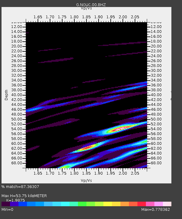
| Estimated Moho Depth: |
53.75 km |
| Estimated Crust Vp/Vs: |
1.99 |
| Assumed Crust Vp: |
5.14 km/s |
| Estimated Crust Vs: |
2.586 km/s |
| Estimated Crust Poisson's Ratio: |
0.33 |
|
| Radial Match: |
87.36307 % |
| Radial Bump: |
400 |
| Transverse Match: |
72.847435 % |
| Transverse Bump: |
318 |
| SOD ConfigId: |
2429771 |
| Insert Time: |
2017-11-14 11:51:17.927 +0000 |
| GWidth: |
2.5 |
| Max Bumps: |
400 |
| Tol: |
0.001 |
|
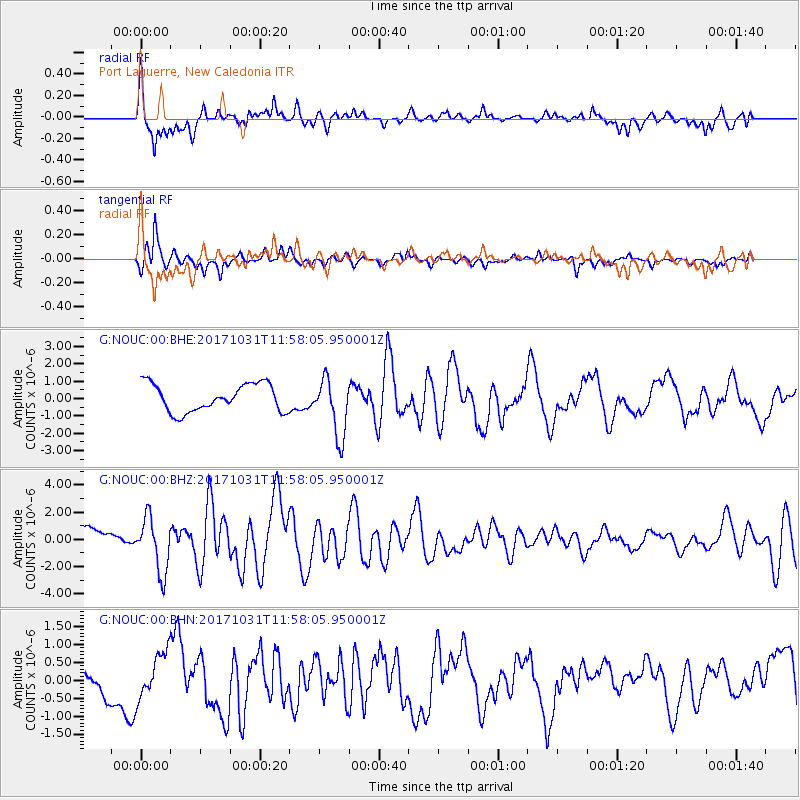
Signal To Noise
| Channel | StoN | STA | LTA |
| G:NOUC:00:BHZ:20171031T11:58:05.950001Z | 3.4802668 | 2.0118143E-6 | 5.780633E-7 |
| G:NOUC:00:BHN:20171031T11:58:05.950001Z | 1.4919833 | 6.323932E-7 | 4.2386077E-7 |
| G:NOUC:00:BHE:20171031T11:58:05.950001Z | 2.1242383 | 1.680862E-6 | 7.9127756E-7 |
| Arrivals |
| Ps | 11 SECOND |
| PpPs | 30 SECOND |
| PsPs/PpSs | 41 SECOND |


