You are here: Home > Network List > US - United States National Seismic Network Stations List
> Station MNTX Cornudas Mountains, Texas, USA > Earthquake Result Viewer
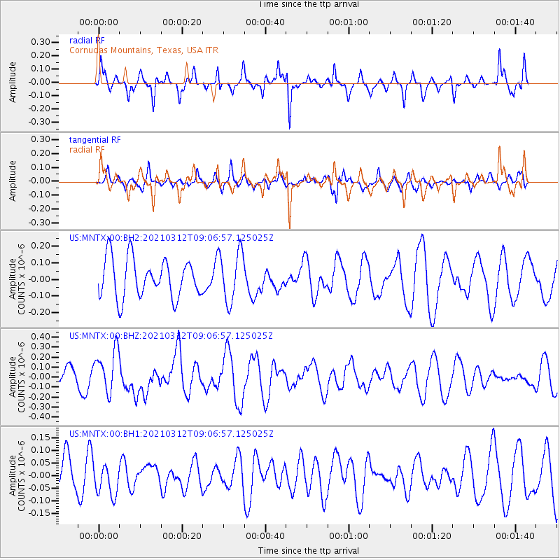
MNTX Cornudas Mountains, Texas, USA - Earthquake Result Viewer
*The percent match for this event was below the threshold and hence no stack was calculated.
| Earthquake location: |
Southeast Of Loyalty Islands |
| Earthquake latitude/longitude: |
-22.4/174.4 |
| Earthquake time(UTC): |
2021/03/12 (071) 08:54:12 GMT |
| Earthquake Depth: |
10 km |
| Earthquake Magnitude: |
5.9 Mww |
| Earthquake Catalog/Contributor: |
NEIC PDE/us |
|
| Network: |
US United States National Seismic Network |
| Station: |
MNTX Cornudas Mountains, Texas, USA |
| Lat/Lon: |
31.70 N/105.38 W |
| Elevation: |
404 m |
|
| Distance: |
93.7 deg |
| Az: |
57.321 deg |
| Baz: |
246.043 deg |
| Ray Param: |
$rayparam |
*The percent match for this event was below the threshold and hence was not used in the summary stack. |
|
| Radial Match: |
69.42535 % |
| Radial Bump: |
290 |
| Transverse Match: |
49.37579 % |
| Transverse Bump: |
399 |
| SOD ConfigId: |
24334971 |
| Insert Time: |
2021-03-26 09:09:51.840 +0000 |
| GWidth: |
2.5 |
| Max Bumps: |
400 |
| Tol: |
0.001 |
|
Signal To Noise
| Channel | StoN | STA | LTA |
| US:MNTX:00:BHZ:20210312T09:06:57.125025Z | 1.818138 | 2.1844076E-7 | 1.2014532E-7 |
| US:MNTX:00:BH1:20210312T09:06:57.125025Z | 0.6705944 | 5.977362E-8 | 8.913528E-8 |
| US:MNTX:00:BH2:20210312T09:06:57.125025Z | 1.2869241 | 1.5209984E-7 | 1.1818866E-7 |
| Arrivals |
| Ps | |
| PpPs | |
| PsPs/PpSs | |


