You are here: Home > Network List > UU - University of Utah Regional Network Stations List
> Station KNB Kanab, UT, USA > Earthquake Result Viewer
KNB Kanab, UT, USA - Earthquake Result Viewer
*The percent match for this event was below the threshold and hence no stack was calculated.
| Earthquake location: |
Southeast Of Loyalty Islands |
| Earthquake latitude/longitude: |
-22.4/174.4 |
| Earthquake time(UTC): |
2021/03/12 (071) 08:54:12 GMT |
| Earthquake Depth: |
10 km |
| Earthquake Magnitude: |
5.9 Mww |
| Earthquake Catalog/Contributor: |
NEIC PDE/us |
|
| Network: |
UU University of Utah Regional Network |
| Station: |
KNB Kanab, UT, USA |
| Lat/Lon: |
37.02 N/112.82 W |
| Elevation: |
1715 m |
|
| Distance: |
90.4 deg |
| Az: |
49.863 deg |
| Baz: |
242.123 deg |
| Ray Param: |
$rayparam |
*The percent match for this event was below the threshold and hence was not used in the summary stack. |
|
| Radial Match: |
61.13643 % |
| Radial Bump: |
286 |
| Transverse Match: |
48.84281 % |
| Transverse Bump: |
400 |
| SOD ConfigId: |
24334971 |
| Insert Time: |
2021-03-26 09:10:11.505 +0000 |
| GWidth: |
2.5 |
| Max Bumps: |
400 |
| Tol: |
0.001 |
|
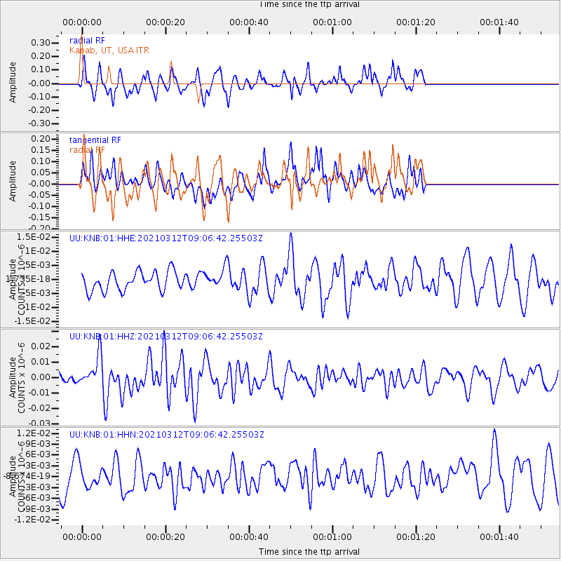
Signal To Noise
| Channel | StoN | STA | LTA |
| UU:KNB:01:HHZ:20210312T09:06:42.25503Z | 3.5898435 | 1.0454204E-8 | 2.9121612E-9 |
| UU:KNB:01:HHN:20210312T09:06:42.25503Z | 0.600832 | 3.0548228E-9 | 5.0843214E-9 |
| UU:KNB:01:HHE:20210312T09:06:42.25503Z | 1.0646343 | 3.5569938E-9 | 3.3410472E-9 |
| Arrivals |
| Ps | |
| PpPs | |
| PsPs/PpSs | |


