You are here: Home > Network List > UU - University of Utah Regional Network Stations List
> Station FSB3 FORGE surface borehole 3, UT, USA > Earthquake Result Viewer
FSB3 FORGE surface borehole 3, UT, USA - Earthquake Result Viewer
| Earthquake location: |
Southeast Of Loyalty Islands |
| Earthquake latitude/longitude: |
-22.4/174.4 |
| Earthquake time(UTC): |
2021/03/12 (071) 08:54:12 GMT |
| Earthquake Depth: |
10 km |
| Earthquake Magnitude: |
5.9 Mww |
| Earthquake Catalog/Contributor: |
NEIC PDE/us |
|
| Network: |
UU University of Utah Regional Network |
| Station: |
FSB3 FORGE surface borehole 3, UT, USA |
| Lat/Lon: |
38.51 N/112.88 W |
| Elevation: |
1701 m |
|
| Distance: |
91.1 deg |
| Az: |
48.52 deg |
| Baz: |
242.105 deg |
| Ray Param: |
0.041646555 |
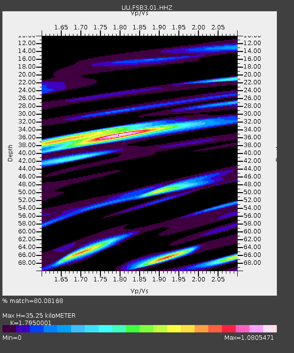
| Estimated Moho Depth: |
35.25 km |
| Estimated Crust Vp/Vs: |
1.80 |
| Assumed Crust Vp: |
6.276 km/s |
| Estimated Crust Vs: |
3.496 km/s |
| Estimated Crust Poisson's Ratio: |
0.27 |
|
| Radial Match: |
80.08168 % |
| Radial Bump: |
400 |
| Transverse Match: |
64.386116 % |
| Transverse Bump: |
400 |
| SOD ConfigId: |
24334971 |
| Insert Time: |
2021-03-26 09:10:30.401 +0000 |
| GWidth: |
2.5 |
| Max Bumps: |
400 |
| Tol: |
0.001 |
|

Signal To Noise
| Channel | StoN | STA | LTA |
| UU:FSB3:01:HHZ:20210312T09:06:45.300013Z | 2.5717688 | 3.6445618E-7 | 1.4171421E-7 |
| UU:FSB3:01:HH1:20210312T09:06:45.300013Z | 1.8208449 | 2.92791E-7 | 1.6079952E-7 |
| UU:FSB3:01:HH2:20210312T09:06:45.300013Z | 1.2070624 | 1.7296394E-7 | 1.4329329E-7 |
| Arrivals |
| Ps | 4.6 SECOND |
| PpPs | 15 SECOND |
| PsPs/PpSs | 20 SECOND |


