You are here: Home > Network List > UW - Pacific Northwest Regional Seismic Network Stations List
> Station FISH Seaside, OR, USA > Earthquake Result Viewer
FISH Seaside, OR, USA - Earthquake Result Viewer
*The percent match for this event was below the threshold and hence no stack was calculated.
| Earthquake location: |
Southeast Of Loyalty Islands |
| Earthquake latitude/longitude: |
-22.4/174.4 |
| Earthquake time(UTC): |
2021/03/12 (071) 08:54:12 GMT |
| Earthquake Depth: |
10 km |
| Earthquake Magnitude: |
5.9 Mww |
| Earthquake Catalog/Contributor: |
NEIC PDE/us |
|
| Network: |
UW Pacific Northwest Regional Seismic Network |
| Station: |
FISH Seaside, OR, USA |
| Lat/Lon: |
45.93 N/123.56 W |
| Elevation: |
325 m |
|
| Distance: |
88.2 deg |
| Az: |
38.078 deg |
| Baz: |
234.864 deg |
| Ray Param: |
$rayparam |
*The percent match for this event was below the threshold and hence was not used in the summary stack. |
|
| Radial Match: |
54.314384 % |
| Radial Bump: |
316 |
| Transverse Match: |
53.071987 % |
| Transverse Bump: |
393 |
| SOD ConfigId: |
24334971 |
| Insert Time: |
2021-03-26 09:10:45.817 +0000 |
| GWidth: |
2.5 |
| Max Bumps: |
400 |
| Tol: |
0.001 |
|
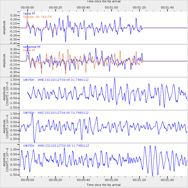
Signal To Noise
| Channel | StoN | STA | LTA |
| UW:FISH: :HHZ:20210312T09:06:31.748011Z | 2.3477128 | 7.4408547E-7 | 3.1694057E-7 |
| UW:FISH: :HHN:20210312T09:06:31.748011Z | 1.2650273 | 6.902518E-7 | 5.456418E-7 |
| UW:FISH: :HHE:20210312T09:06:31.748011Z | 1.09693 | 3.91318E-7 | 3.5673926E-7 |
| Arrivals |
| Ps | |
| PpPs | |
| PsPs/PpSs | |


