You are here: Home > Network List > GE - GEOFON Stations List
> Station MLR GEOFON Station Muntele Rosu, Romania > Earthquake Result Viewer
MLR GEOFON Station Muntele Rosu, Romania - Earthquake Result Viewer
| Earthquake location: |
Lake Tanganyika Region |
| Earthquake latitude/longitude: |
-8.0/30.7 |
| Earthquake time(UTC): |
2000/10/02 (276) 02:25:31 GMT |
| Earthquake Depth: |
34 km |
| Earthquake Magnitude: |
6.1 MB, 6.7 MS, 6.5 MW, 6.2 ME |
| Earthquake Catalog/Contributor: |
WHDF/NEIC |
|
| Network: |
GE GEOFON |
| Station: |
MLR GEOFON Station Muntele Rosu, Romania |
| Lat/Lon: |
45.49 N/25.95 E |
| Elevation: |
1378 m |
|
| Distance: |
53.4 deg |
| Az: |
355.827 deg |
| Baz: |
174.119 deg |
| Ray Param: |
0.06606317 |
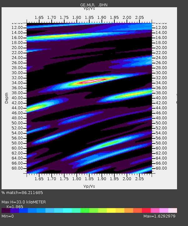
| Estimated Moho Depth: |
33.0 km |
| Estimated Crust Vp/Vs: |
1.87 |
| Assumed Crust Vp: |
6.194 km/s |
| Estimated Crust Vs: |
3.321 km/s |
| Estimated Crust Poisson's Ratio: |
0.30 |
|
| Radial Match: |
86.211685 % |
| Radial Bump: |
400 |
| Transverse Match: |
84.70139 % |
| Transverse Bump: |
400 |
| SOD ConfigId: |
3744 |
| Insert Time: |
2010-03-09 06:25:58.104 +0000 |
| GWidth: |
2.5 |
| Max Bumps: |
400 |
| Tol: |
0.001 |
|

Signal To Noise
| Channel | StoN | STA | LTA |
| GE:MLR: :BHN:20001002T02:34:16.999026Z | 3.053022 | 5.412388E-7 | 1.772797E-7 |
| GE:MLR: :BHE:20001002T02:34:16.999026Z | 2.6814845 | 2.7116363E-7 | 1.01124435E-7 |
| GE:MLR: :BHZ:20001002T02:34:16.999026Z | 15.685688 | 2.2496388E-6 | 1.4341984E-7 |
| Arrivals |
| Ps | 4.8 SECOND |
| PpPs | 15 SECOND |
| PsPs/PpSs | 19 SECOND |


