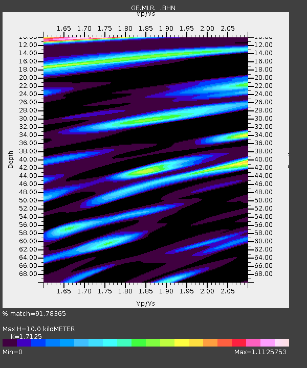
MLR GEOFON Station Muntele Rosu, Romania - Earthquake Result Viewer

Earthquake location: Southern Sumatra, Indonesia
Earthquake latitude/longitude: -4.7/102.1
Earthquake time(UTC): 2000/06/04 (156) 16:28:26 GMT
Earthquake Depth: 33 km
Earthquake Magnitude: 6.8 MB, 8.0 MS, 7.9 MW, 7.7 MW
Earthquake Catalog/Contributor: WHDF/NEIC
Network: GE GEOFON
Station: MLR GEOFON Station Muntele Rosu, Romania
Lat/Lon: 45.49 N/25.95 E
Elevation: 1378 m
Distance: 83.7 deg
Az: 316.6 deg
Baz: 103.213 deg
Ray Param: 0.045960587
Estimated Moho Depth: 10.0 km
Estimated Crust Vp/Vs: 1.71
Assumed Crust Vp: 6.194 km/s
Estimated Crust Vs: 3.617 km/s
Estimated Crust Poisson's Ratio: 0.24
Radial Match: 91.78365 %
Radial Bump: 400
Transverse Match: 94.632286 %
Transverse Bump: 400
SOD ConfigId: 3744
Insert Time: 2010-03-09 06:26:10.621 +0000
GWidth: 2.5
Max Bumps: 400
Tol: 0.001

Signal To Noise

ChannelStoNSTALTA
GE:MLR: :BHN:20000604T16:40:20.469011Z0.920082039.389651E-81.02052326E-7
GE:MLR: :BHE:20000604T16:40:20.469011Z0.91143641.1445442E-71.2557588E-7
GE:MLR: :BHZ:20000604T16:40:20.469011Z1.43349473.2729227E-72.2831773E-7
Arrivals
Ps1.2 SECOND
PpPs4.3 SECOND
PsPs/PpSs5.5 SECOND