You are here: Home > Network List > IU - Global Seismograph Network (GSN - IRIS/USGS) Stations List
> Station SNZO South Karori, New Zealand > Earthquake Result Viewer
SNZO South Karori, New Zealand - Earthquake Result Viewer
| Earthquake location: |
Seram, Indonesia |
| Earthquake latitude/longitude: |
-3.7/127.8 |
| Earthquake time(UTC): |
2017/10/31 (304) 11:50:51 GMT |
| Earthquake Depth: |
32 km |
| Earthquake Magnitude: |
6.3 Mww |
| Earthquake Catalog/Contributor: |
NEIC PDE/us |
|
| Network: |
IU Global Seismograph Network (GSN - IRIS/USGS) |
| Station: |
SNZO South Karori, New Zealand |
| Lat/Lon: |
41.31 S/174.70 E |
| Elevation: |
120 m |
|
| Distance: |
56.2 deg |
| Az: |
138.574 deg |
| Baz: |
298.781 deg |
| Ray Param: |
0.06422503 |
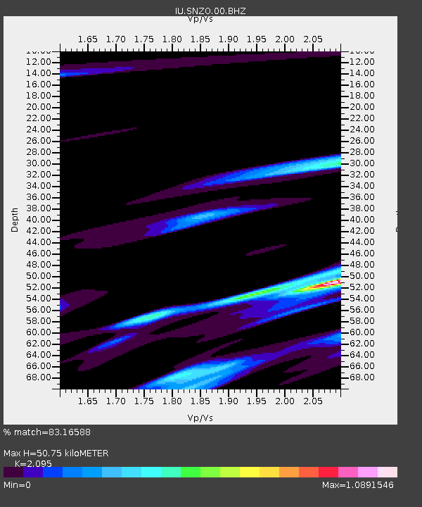
| Estimated Moho Depth: |
50.75 km |
| Estimated Crust Vp/Vs: |
2.10 |
| Assumed Crust Vp: |
6.461 km/s |
| Estimated Crust Vs: |
3.084 km/s |
| Estimated Crust Poisson's Ratio: |
0.35 |
|
| Radial Match: |
83.16588 % |
| Radial Bump: |
381 |
| Transverse Match: |
69.586235 % |
| Transverse Bump: |
381 |
| SOD ConfigId: |
2429771 |
| Insert Time: |
2017-11-14 11:52:04.244 +0000 |
| GWidth: |
2.5 |
| Max Bumps: |
400 |
| Tol: |
0.001 |
|
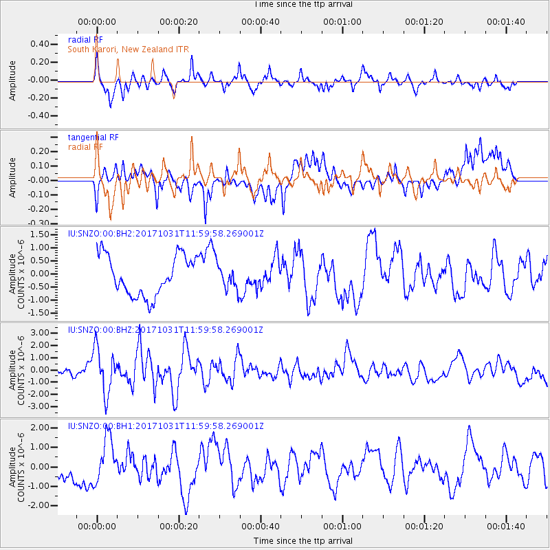
Signal To Noise
| Channel | StoN | STA | LTA |
| IU:SNZO:00:BHZ:20171031T11:59:58.269001Z | 4.619119 | 1.8796841E-6 | 4.069356E-7 |
| IU:SNZO:00:BH1:20171031T11:59:58.269001Z | 2.1851425 | 1.1640204E-6 | 5.326977E-7 |
| IU:SNZO:00:BH2:20171031T11:59:58.269001Z | 0.6130147 | 4.590912E-7 | 7.489073E-7 |
| Arrivals |
| Ps | 9.0 SECOND |
| PpPs | 23 SECOND |
| PsPs/PpSs | 32 SECOND |


