You are here: Home > Network List > ND - New CaleDonia Broadband Seismic Network Stations List
> Station OUENC Ouen island, New Caledonia > Earthquake Result Viewer
OUENC Ouen island, New Caledonia - Earthquake Result Viewer

| Earthquake location: |
Seram, Indonesia |
| Earthquake latitude/longitude: |
-3.7/127.8 |
| Earthquake time(UTC): |
2017/10/31 (304) 11:50:51 GMT |
| Earthquake Depth: |
32 km |
| Earthquake Magnitude: |
6.3 Mww |
| Earthquake Catalog/Contributor: |
NEIC PDE/us |
|
| Network: |
ND New CaleDonia Broadband Seismic Network |
| Station: |
OUENC Ouen island, New Caledonia |
| Lat/Lon: |
22.42 S/166.84 E |
| Elevation: |
115 m |
|
| Distance: |
42.1 deg |
| Az: |
119.698 deg |
| Baz: |
290.475 deg |
| Ray Param: |
0.07329518 |
| Estimated Moho Depth: |
68.0 km |
| Estimated Crust Vp/Vs: |
1.69 |
| Assumed Crust Vp: |
5.14 km/s |
| Estimated Crust Vs: |
3.05 km/s |
| Estimated Crust Poisson's Ratio: |
0.23 |
|
| Radial Match: |
82.983215 % |
| Radial Bump: |
400 |
| Transverse Match: |
68.31622 % |
| Transverse Bump: |
400 |
| SOD ConfigId: |
2429771 |
| Insert Time: |
2017-11-14 11:52:25.133 +0000 |
| GWidth: |
2.5 |
| Max Bumps: |
400 |
| Tol: |
0.001 |
|
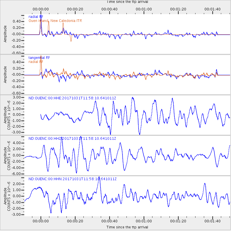
Signal To Noise
| Channel | StoN | STA | LTA |
| ND:OUENC:00:HHZ:20171031T11:58:10.641011Z | 3.795818 | 2.5821846E-6 | 6.802709E-7 |
| ND:OUENC:00:HHN:20171031T11:58:10.641011Z | 1.6091331 | 9.910018E-7 | 6.1586064E-7 |
| ND:OUENC:00:HHE:20171031T11:58:10.641011Z | 3.1314976 | 1.4864167E-6 | 4.746664E-7 |
| Arrivals |
| Ps | 9.5 SECOND |
| PpPs | 34 SECOND |
| PsPs/PpSs | 43 SECOND |


