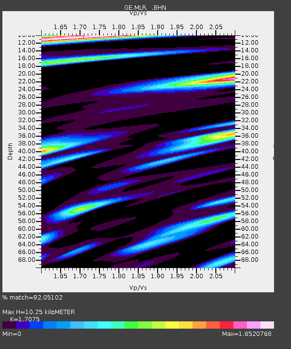
MLR GEOFON Station Muntele Rosu, Romania - Earthquake Result Viewer

Earthquake location: Western Xizang-India Border Reg.
Earthquake latitude/longitude: 30.5/79.4
Earthquake time(UTC): 1999/03/28 (087) 19:05:11 GMT
Earthquake Depth: 15 km
Earthquake Magnitude: 6.4 MB, 6.6 MS, 6.6 MW, 6.5 ME
Earthquake Catalog/Contributor: WHDF/NEIC
Network: GE GEOFON
Station: MLR GEOFON Station Muntele Rosu, Romania
Lat/Lon: 45.49 N/25.95 E
Elevation: 1378 m
Distance: 43.9 deg
Az: 305.414 deg
Baz: 90.817 deg
Ray Param: 0.07223664
Estimated Moho Depth: 10.25 km
Estimated Crust Vp/Vs: 1.71
Assumed Crust Vp: 6.194 km/s
Estimated Crust Vs: 3.628 km/s
Estimated Crust Poisson's Ratio: 0.24
Radial Match: 92.05102 %
Radial Bump: 369
Transverse Match: 88.10187 %
Transverse Bump: 386
SOD ConfigId: 4480
Insert Time: 2010-03-09 06:26:34.369 +0000
GWidth: 2.5
Max Bumps: 400
Tol: 0.001

Signal To Noise

ChannelStoNSTALTA
GE:MLR: :BHN:19990328T19:12:46.05301Z1.91249671.6399173E-78.5747466E-8
GE:MLR: :BHE:19990328T19:12:46.05301Z1.58557781.9229873E-71.2127991E-7
GE:MLR: :BHZ:19990328T19:12:46.05301Z1.98562612.4786402E-71.2482916E-7
Arrivals
Ps1.2 SECOND
PpPs4.2 SECOND
PsPs/PpSs5.5 SECOND