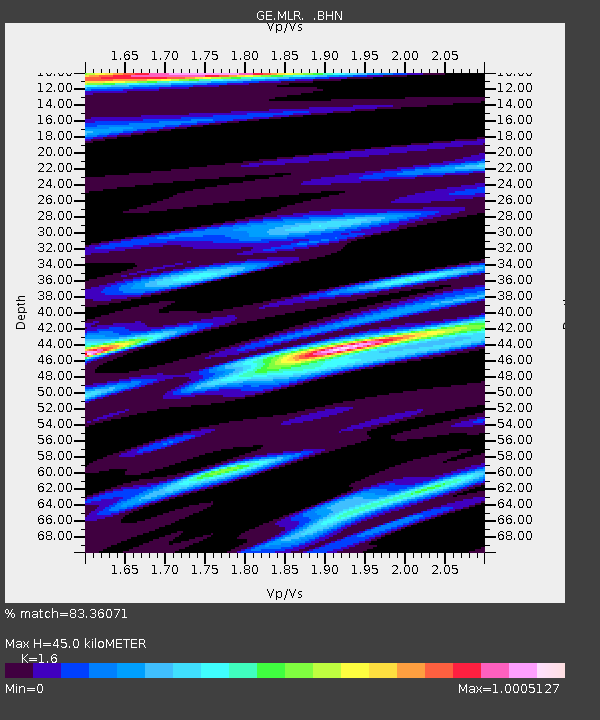
MLR GEOFON Station Muntele Rosu, Romania - Earthquake Result Viewer

Earthquake location: Minahassa Peninsula, Sulawesi
Earthquake latitude/longitude: 1.2/122.5
Earthquake time(UTC): 1997/11/25 (329) 12:14:33 GMT
Earthquake Depth: 24 km
Earthquake Magnitude: 6.1 MB, 6.8 MS, 7.1 UNKNOWN, 6.7 ME
Earthquake Catalog/Contributor: WHDF/NEIC
Network: GE GEOFON
Station: MLR GEOFON Station Muntele Rosu, Romania
Lat/Lon: 45.49 N/25.95 E
Elevation: 1378 m
Distance: 93.8 deg
Az: 315.552 deg
Baz: 84.439 deg
Ray Param: 0.04119243
Estimated Moho Depth: 45.0 km
Estimated Crust Vp/Vs: 1.60
Assumed Crust Vp: 6.194 km/s
Estimated Crust Vs: 3.871 km/s
Estimated Crust Poisson's Ratio: 0.18
Radial Match: 83.36071 %
Radial Bump: 400
Transverse Match: 79.39243 %
Transverse Bump: 400
SOD ConfigId: 4480
Insert Time: 2010-03-09 06:26:56.219 +0000
GWidth: 2.5
Max Bumps: 400
Tol: 0.001

Signal To Noise

ChannelStoNSTALTA
GE:MLR: :BHN:19971125T12:27:16.828027Z7.9174085.998041E-77.575763E-8
GE:MLR: :BHE:19971125T12:27:16.828027Z0.87563819.071445E-81.03598104E-7
GE:MLR: :BHZ:19971125T12:27:16.828027Z2.29492122.0777387E-79.053638E-8
Arrivals
Ps4.5 SECOND
PpPs18 SECOND
PsPs/PpSs23 SECOND