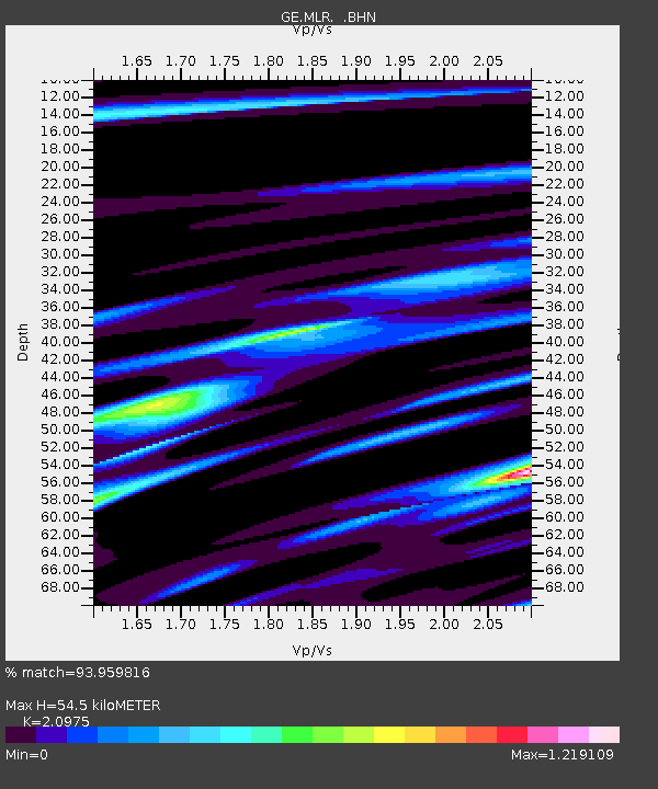
MLR GEOFON Station Muntele Rosu, Romania - Earthquake Result Viewer

Earthquake location: Near East Coast Of Kamchatka
Earthquake latitude/longitude: 54.8/162.0
Earthquake time(UTC): 1997/12/05 (339) 11:26:54 GMT
Earthquake Depth: 33 km
Earthquake Magnitude: 6.3 MB, 7.6 MS, 7.9 UNKNOWN, 7.3 ME
Earthquake Catalog/Contributor: WHDF/NEIC
Network: GE GEOFON
Station: MLR GEOFON Station Muntele Rosu, Romania
Lat/Lon: 45.49 N/25.95 E
Elevation: 1378 m
Distance: 73.3 deg
Az: 329.389 deg
Baz: 24.755 deg
Ray Param: 0.05302073
Estimated Moho Depth: 54.5 km
Estimated Crust Vp/Vs: 2.10
Assumed Crust Vp: 6.194 km/s
Estimated Crust Vs: 2.953 km/s
Estimated Crust Poisson's Ratio: 0.35
Radial Match: 93.959816 %
Radial Bump: 400
Transverse Match: 88.31461 %
Transverse Bump: 400
SOD ConfigId: 4480
Insert Time: 2010-03-09 06:27:11.914 +0000
GWidth: 2.5
Max Bumps: 400
Tol: 0.001

Signal To Noise

ChannelStoNSTALTA
GE:MLR: :BHN:19971205T11:37:52.027002Z9.6864163.0006056E-63.097746E-7
GE:MLR: :BHE:19971205T11:37:52.027002Z5.1667251.1917159E-62.3065208E-7
GE:MLR: :BHZ:19971205T11:37:52.027002Z1.54959314.446551E-72.869496E-7
Arrivals
Ps9.9 SECOND
PpPs27 SECOND
PsPs/PpSs36 SECOND