You are here: Home > Network List > AE - Arizona Broadband Seismic Network Stations List
> Station TONTO Roosevelt/Tonto Basin > Earthquake Result Viewer
TONTO Roosevelt/Tonto Basin - Earthquake Result Viewer
| Earthquake location: |
Kermadec Islands, New Zealand |
| Earthquake latitude/longitude: |
-29.9/-177.9 |
| Earthquake time(UTC): |
2021/03/13 (072) 14:05:01 GMT |
| Earthquake Depth: |
37 km |
| Earthquake Magnitude: |
5.9 mww |
| Earthquake Catalog/Contributor: |
NEIC PDE/us |
|
| Network: |
AE Arizona Broadband Seismic Network |
| Station: |
TONTO Roosevelt/Tonto Basin |
| Lat/Lon: |
33.65 N/111.01 W |
| Elevation: |
661 m |
|
| Distance: |
89.3 deg |
| Az: |
50.087 deg |
| Baz: |
233.016 deg |
| Ray Param: |
0.041887328 |
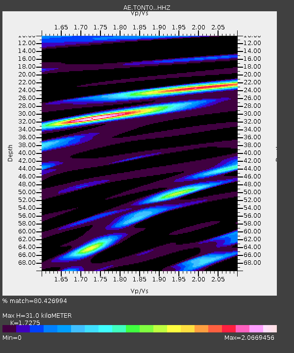
| Estimated Moho Depth: |
31.0 km |
| Estimated Crust Vp/Vs: |
1.73 |
| Assumed Crust Vp: |
6.276 km/s |
| Estimated Crust Vs: |
3.633 km/s |
| Estimated Crust Poisson's Ratio: |
0.25 |
|
| Radial Match: |
80.426994 % |
| Radial Bump: |
328 |
| Transverse Match: |
72.57994 % |
| Transverse Bump: |
400 |
| SOD ConfigId: |
24334971 |
| Insert Time: |
2021-03-27 14:06:39.445 +0000 |
| GWidth: |
2.5 |
| Max Bumps: |
400 |
| Tol: |
0.001 |
|

Signal To Noise
| Channel | StoN | STA | LTA |
| AE:TONTO: :HHZ:20210313T14:17:22.790025Z | 5.311325 | 6.090169E-7 | 1.1466384E-7 |
| AE:TONTO: :HHN:20210313T14:17:22.790025Z | 1.0533819 | 1.7004615E-7 | 1.6142877E-7 |
| AE:TONTO: :HHE:20210313T14:17:22.790025Z | 0.6854835 | 1.5250122E-7 | 2.2247248E-7 |
| Arrivals |
| Ps | 3.7 SECOND |
| PpPs | 13 SECOND |
| PsPs/PpSs | 17 SECOND |


