You are here: Home > Network List > US - United States National Seismic Network Stations List
> Station ELK Elko, Nevada, USA > Earthquake Result Viewer
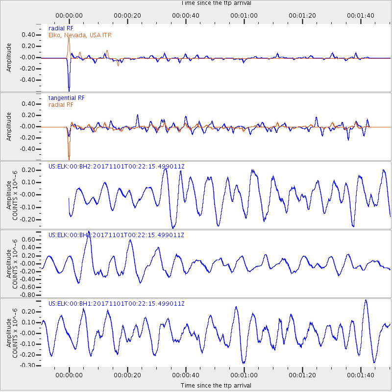
ELK Elko, Nevada, USA - Earthquake Result Viewer
*The percent match for this event was below the threshold and hence no stack was calculated.
| Earthquake location: |
Loyalty Islands |
| Earthquake latitude/longitude: |
-21.7/168.9 |
| Earthquake time(UTC): |
2017/11/01 (305) 00:09:29 GMT |
| Earthquake Depth: |
10 km |
| Earthquake Magnitude: |
6.1 Mww |
| Earthquake Catalog/Contributor: |
NEIC PDE/us |
|
| Network: |
US United States National Seismic Network |
| Station: |
ELK Elko, Nevada, USA |
| Lat/Lon: |
40.74 N/115.24 W |
| Elevation: |
2210 m |
|
| Distance: |
93.8 deg |
| Az: |
47.585 deg |
| Baz: |
244.618 deg |
| Ray Param: |
$rayparam |
*The percent match for this event was below the threshold and hence was not used in the summary stack. |
|
| Radial Match: |
90.84744 % |
| Radial Bump: |
267 |
| Transverse Match: |
67.98036 % |
| Transverse Bump: |
400 |
| SOD ConfigId: |
2429771 |
| Insert Time: |
2017-11-15 00:11:22.023 +0000 |
| GWidth: |
2.5 |
| Max Bumps: |
400 |
| Tol: |
0.001 |
|
Signal To Noise
| Channel | StoN | STA | LTA |
| US:ELK:00:BHZ:20171101T00:22:15.499011Z | 2.3287952 | 2.546669E-7 | 1.09355646E-7 |
| US:ELK:00:BH1:20171101T00:22:15.499011Z | 1.0804336 | 1.008379E-7 | 9.3330954E-8 |
| US:ELK:00:BH2:20171101T00:22:15.499011Z | 2.0707445 | 1.2882589E-7 | 6.221235E-8 |
| Arrivals |
| Ps | |
| PpPs | |
| PsPs/PpSs | |


