You are here: Home > Network List > US - United States National Seismic Network Stations List
> Station MSO Missoula, Montana, USA > Earthquake Result Viewer
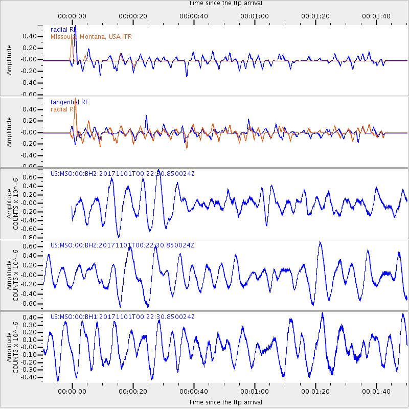
MSO Missoula, Montana, USA - Earthquake Result Viewer
*The percent match for this event was below the threshold and hence no stack was calculated.
| Earthquake location: |
Loyalty Islands |
| Earthquake latitude/longitude: |
-21.7/168.9 |
| Earthquake time(UTC): |
2017/11/01 (305) 00:09:29 GMT |
| Earthquake Depth: |
10 km |
| Earthquake Magnitude: |
6.1 Mww |
| Earthquake Catalog/Contributor: |
NEIC PDE/us |
|
| Network: |
US United States National Seismic Network |
| Station: |
MSO Missoula, Montana, USA |
| Lat/Lon: |
46.83 N/113.94 W |
| Elevation: |
1264 m |
|
| Distance: |
97.2 deg |
| Az: |
42.429 deg |
| Baz: |
246.009 deg |
| Ray Param: |
$rayparam |
*The percent match for this event was below the threshold and hence was not used in the summary stack. |
|
| Radial Match: |
63.437675 % |
| Radial Bump: |
400 |
| Transverse Match: |
57.137672 % |
| Transverse Bump: |
400 |
| SOD ConfigId: |
2429771 |
| Insert Time: |
2017-11-15 00:11:26.096 +0000 |
| GWidth: |
2.5 |
| Max Bumps: |
400 |
| Tol: |
0.001 |
|
Signal To Noise
| Channel | StoN | STA | LTA |
| US:MSO:00:BHZ:20171101T00:22:30.850024Z | 0.56191623 | 1.5527304E-7 | 2.7632774E-7 |
| US:MSO:00:BH1:20171101T00:22:30.850024Z | 1.7281424 | 2.3931116E-7 | 1.3847884E-7 |
| US:MSO:00:BH2:20171101T00:22:30.850024Z | 1.1797968 | 3.7713423E-7 | 3.1966033E-7 |
| Arrivals |
| Ps | |
| PpPs | |
| PsPs/PpSs | |


