You are here: Home > Network List > CI - Caltech Regional Seismic Network Stations List
> Station MPM Manuel Prospect Mine, California, USA > Earthquake Result Viewer
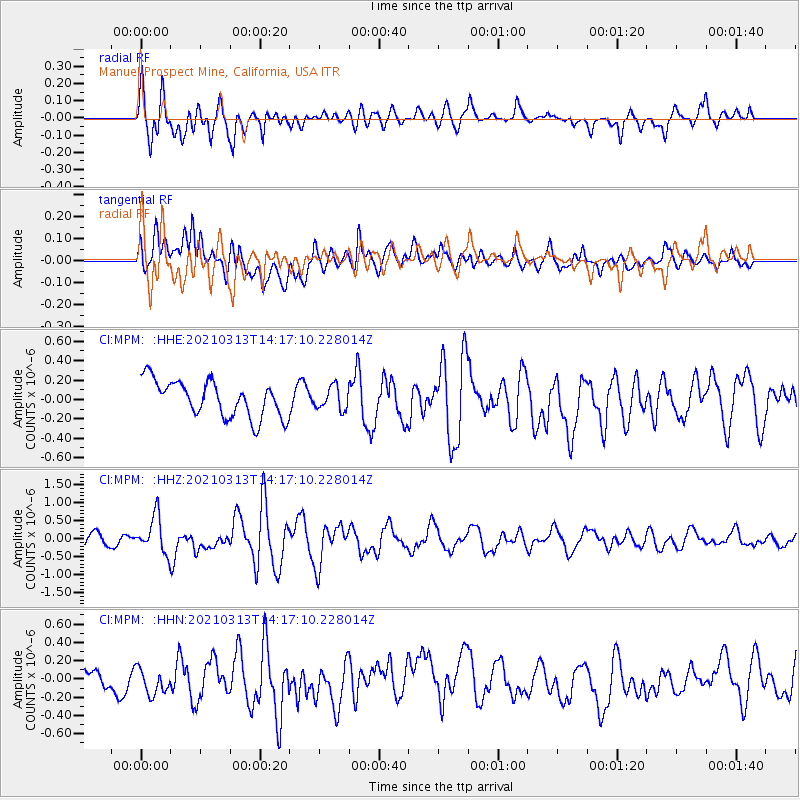
MPM Manuel Prospect Mine, California, USA - Earthquake Result Viewer
*The percent match for this event was below the threshold and hence no stack was calculated.
| Earthquake location: |
Kermadec Islands, New Zealand |
| Earthquake latitude/longitude: |
-29.9/-177.9 |
| Earthquake time(UTC): |
2021/03/13 (072) 14:05:01 GMT |
| Earthquake Depth: |
37 km |
| Earthquake Magnitude: |
5.9 mww |
| Earthquake Catalog/Contributor: |
NEIC PDE/us |
|
| Network: |
CI Caltech Regional Seismic Network |
| Station: |
MPM Manuel Prospect Mine, California, USA |
| Lat/Lon: |
36.06 N/117.49 W |
| Elevation: |
185 m |
|
| Distance: |
86.7 deg |
| Az: |
44.868 deg |
| Baz: |
229.143 deg |
| Ray Param: |
$rayparam |
*The percent match for this event was below the threshold and hence was not used in the summary stack. |
|
| Radial Match: |
72.88088 % |
| Radial Bump: |
400 |
| Transverse Match: |
52.085953 % |
| Transverse Bump: |
400 |
| SOD ConfigId: |
24334971 |
| Insert Time: |
2021-03-27 14:13:41.692 +0000 |
| GWidth: |
2.5 |
| Max Bumps: |
400 |
| Tol: |
0.001 |
|
Signal To Noise
| Channel | StoN | STA | LTA |
| CI:MPM: :HHZ:20210313T14:17:10.228014Z | 2.9651704 | 5.1102484E-7 | 1.723425E-7 |
| CI:MPM: :HHN:20210313T14:17:10.228014Z | 1.0603374 | 1.521048E-7 | 1.4344943E-7 |
| CI:MPM: :HHE:20210313T14:17:10.228014Z | 0.6320207 | 1.1767331E-7 | 1.8618584E-7 |
| Arrivals |
| Ps | |
| PpPs | |
| PsPs/PpSs | |


