You are here: Home > Network List > US - United States National Seismic Network Stations List
> Station MNTX Cornudas Mountains, Texas, USA > Earthquake Result Viewer
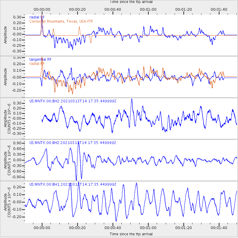
MNTX Cornudas Mountains, Texas, USA - Earthquake Result Viewer
*The percent match for this event was below the threshold and hence no stack was calculated.
| Earthquake location: |
Kermadec Islands, New Zealand |
| Earthquake latitude/longitude: |
-29.9/-177.9 |
| Earthquake time(UTC): |
2021/03/13 (072) 14:05:01 GMT |
| Earthquake Depth: |
37 km |
| Earthquake Magnitude: |
5.9 mww |
| Earthquake Catalog/Contributor: |
NEIC PDE/us |
|
| Network: |
US United States National Seismic Network |
| Station: |
MNTX Cornudas Mountains, Texas, USA |
| Lat/Lon: |
31.70 N/105.38 W |
| Elevation: |
404 m |
|
| Distance: |
92.1 deg |
| Az: |
54.424 deg |
| Baz: |
235.988 deg |
| Ray Param: |
$rayparam |
*The percent match for this event was below the threshold and hence was not used in the summary stack. |
|
| Radial Match: |
63.956642 % |
| Radial Bump: |
400 |
| Transverse Match: |
74.29926 % |
| Transverse Bump: |
400 |
| SOD ConfigId: |
24334971 |
| Insert Time: |
2021-03-27 14:21:26.878 +0000 |
| GWidth: |
2.5 |
| Max Bumps: |
400 |
| Tol: |
0.001 |
|
Signal To Noise
| Channel | StoN | STA | LTA |
| US:MNTX:00:BHZ:20210313T14:17:35.449999Z | 4.7775507 | 3.7880648E-7 | 7.9288846E-8 |
| US:MNTX:00:BH1:20210313T14:17:35.449999Z | 0.80405855 | 5.654781E-8 | 7.032798E-8 |
| US:MNTX:00:BH2:20210313T14:17:35.449999Z | 0.80458415 | 8.163359E-8 | 1.0146059E-7 |
| Arrivals |
| Ps | |
| PpPs | |
| PsPs/PpSs | |


