You are here: Home > Network List > AK - Alaska Regional Network Stations List
> Station O14K Tigyukauivet Mountain, AK, USA > Earthquake Result Viewer
O14K Tigyukauivet Mountain, AK, USA - Earthquake Result Viewer
| Earthquake location: |
East Of North Island, N.Z. |
| Earthquake latitude/longitude: |
-37.8/-179.5 |
| Earthquake time(UTC): |
2021/03/04 (063) 13:27:35 GMT |
| Earthquake Depth: |
10 km |
| Earthquake Magnitude: |
7.3 Mi |
| Earthquake Catalog/Contributor: |
NEIC PDE/at |
|
| Network: |
AK Alaska Regional Network |
| Station: |
O14K Tigyukauivet Mountain, AK, USA |
| Lat/Lon: |
59.25 N/161.26 W |
| Elevation: |
129 m |
|
| Distance: |
97.9 deg |
| Az: |
9.341 deg |
| Baz: |
194.492 deg |
| Ray Param: |
0.040080283 |
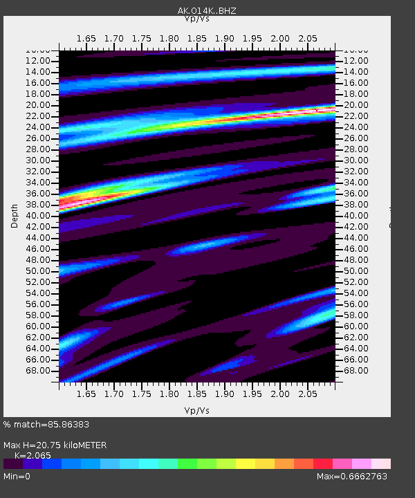
| Estimated Moho Depth: |
20.75 km |
| Estimated Crust Vp/Vs: |
2.07 |
| Assumed Crust Vp: |
6.24 km/s |
| Estimated Crust Vs: |
3.022 km/s |
| Estimated Crust Poisson's Ratio: |
0.35 |
|
| Radial Match: |
85.86383 % |
| Radial Bump: |
400 |
| Transverse Match: |
68.14631 % |
| Transverse Bump: |
400 |
| SOD ConfigId: |
24334971 |
| Insert Time: |
2021-03-29 23:37:16.201 +0000 |
| GWidth: |
2.5 |
| Max Bumps: |
400 |
| Tol: |
0.001 |
|

Signal To Noise
| Channel | StoN | STA | LTA |
| AK:O14K: :BHZ:20210304T13:40:38.940002Z | 5.9131446 | 1.6081053E-6 | 2.7195435E-7 |
| AK:O14K: :BHN:20210304T13:40:38.940002Z | 1.3226653 | 6.151103E-7 | 4.6505366E-7 |
| AK:O14K: :BHE:20210304T13:40:38.940002Z | 0.29832152 | 1.4352392E-7 | 4.811048E-7 |
| Arrivals |
| Ps | 3.6 SECOND |
| PpPs | 10 SECOND |
| PsPs/PpSs | 14 SECOND |


