You are here: Home > Network List > AV - Alaska Volcano Observatory Stations List
> Station AKBB Akutan Broiad Bright, Akutan Volcano, Alaska > Earthquake Result Viewer
AKBB Akutan Broiad Bright, Akutan Volcano, Alaska - Earthquake Result Viewer
| Earthquake location: |
East Of North Island, N.Z. |
| Earthquake latitude/longitude: |
-37.8/-179.5 |
| Earthquake time(UTC): |
2021/03/04 (063) 13:27:35 GMT |
| Earthquake Depth: |
10 km |
| Earthquake Magnitude: |
7.3 Mi |
| Earthquake Catalog/Contributor: |
NEIC PDE/at |
|
| Network: |
AV Alaska Volcano Observatory |
| Station: |
AKBB Akutan Broiad Bright, Akutan Volcano, Alaska |
| Lat/Lon: |
54.10 N/165.93 W |
| Elevation: |
310 m |
|
| Distance: |
92.3 deg |
| Az: |
7.948 deg |
| Baz: |
190.717 deg |
| Ray Param: |
0.041485757 |
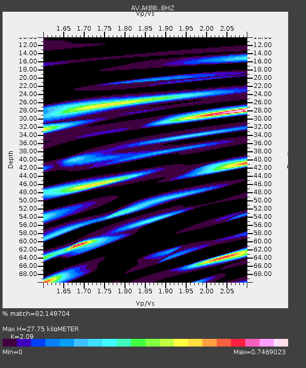
| Estimated Moho Depth: |
27.75 km |
| Estimated Crust Vp/Vs: |
2.09 |
| Assumed Crust Vp: |
5.989 km/s |
| Estimated Crust Vs: |
2.866 km/s |
| Estimated Crust Poisson's Ratio: |
0.35 |
|
| Radial Match: |
82.149704 % |
| Radial Bump: |
400 |
| Transverse Match: |
75.36431 % |
| Transverse Bump: |
400 |
| SOD ConfigId: |
24334971 |
| Insert Time: |
2021-03-29 23:38:41.770 +0000 |
| GWidth: |
2.5 |
| Max Bumps: |
400 |
| Tol: |
0.001 |
|

Signal To Noise
| Channel | StoN | STA | LTA |
| AV:AKBB: :BHZ:20210304T13:40:13.539978Z | 5.049044 | 2.6650305E-6 | 5.2782866E-7 |
| AV:AKBB: :BHN:20210304T13:40:13.539978Z | 1.4134976 | 1.2526597E-6 | 8.862128E-7 |
| AV:AKBB: :BHE:20210304T13:40:13.539978Z | 0.99340105 | 8.085839E-7 | 8.139551E-7 |
| Arrivals |
| Ps | 5.1 SECOND |
| PpPs | 14 SECOND |
| PsPs/PpSs | 19 SECOND |


