You are here: Home > Network List > AV - Alaska Volcano Observatory Stations List
> Station TAFP Falls Point, Tanaga Volcano, Alaska > Earthquake Result Viewer
TAFP Falls Point, Tanaga Volcano, Alaska - Earthquake Result Viewer
| Earthquake location: |
East Of North Island, N.Z. |
| Earthquake latitude/longitude: |
-37.8/-179.5 |
| Earthquake time(UTC): |
2021/03/04 (063) 13:27:35 GMT |
| Earthquake Depth: |
10 km |
| Earthquake Magnitude: |
7.3 Mi |
| Earthquake Catalog/Contributor: |
NEIC PDE/at |
|
| Network: |
AV Alaska Volcano Observatory |
| Station: |
TAFP Falls Point, Tanaga Volcano, Alaska |
| Lat/Lon: |
51.90 N/177.99 W |
| Elevation: |
440 m |
|
| Distance: |
89.3 deg |
| Az: |
0.939 deg |
| Baz: |
181.2 deg |
| Ray Param: |
0.04192925 |
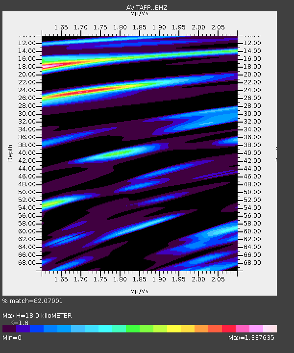
| Estimated Moho Depth: |
18.0 km |
| Estimated Crust Vp/Vs: |
1.60 |
| Assumed Crust Vp: |
5.88 km/s |
| Estimated Crust Vs: |
3.675 km/s |
| Estimated Crust Poisson's Ratio: |
0.18 |
|
| Radial Match: |
82.07001 % |
| Radial Bump: |
400 |
| Transverse Match: |
68.97625 % |
| Transverse Bump: |
400 |
| SOD ConfigId: |
24334971 |
| Insert Time: |
2021-03-29 23:39:54.231 +0000 |
| GWidth: |
2.5 |
| Max Bumps: |
400 |
| Tol: |
0.001 |
|

Signal To Noise
| Channel | StoN | STA | LTA |
| AV:TAFP: :BHZ:20210304T13:39:59.939026Z | 5.2567425 | 5.3449676E-6 | 1.0167832E-6 |
| AV:TAFP: :BHN:20210304T13:39:59.939026Z | 1.2406827 | 1.3263383E-6 | 1.0690392E-6 |
| AV:TAFP: :BHE:20210304T13:39:59.939026Z | 0.6301694 | 1.2705318E-6 | 2.0161751E-6 |
| Arrivals |
| Ps | 1.9 SECOND |
| PpPs | 7.8 SECOND |
| PsPs/PpSs | 9.7 SECOND |


