You are here: Home > Network List > G - GEOSCOPE Stations List
> Station INU Inuyama, Japan > Earthquake Result Viewer
INU Inuyama, Japan - Earthquake Result Viewer
| Earthquake location: |
East Of North Island, N.Z. |
| Earthquake latitude/longitude: |
-37.8/-179.5 |
| Earthquake time(UTC): |
2021/03/04 (063) 13:27:35 GMT |
| Earthquake Depth: |
10 km |
| Earthquake Magnitude: |
7.3 Mi |
| Earthquake Catalog/Contributor: |
NEIC PDE/at |
|
| Network: |
G GEOSCOPE |
| Station: |
INU Inuyama, Japan |
| Lat/Lon: |
35.35 N/137.03 E |
| Elevation: |
132 m |
|
| Distance: |
83.2 deg |
| Az: |
325.501 deg |
| Baz: |
146.712 deg |
| Ray Param: |
0.04635774 |
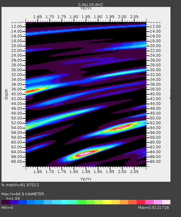
| Estimated Moho Depth: |
64.5 km |
| Estimated Crust Vp/Vs: |
1.84 |
| Assumed Crust Vp: |
6.461 km/s |
| Estimated Crust Vs: |
3.512 km/s |
| Estimated Crust Poisson's Ratio: |
0.29 |
|
| Radial Match: |
91.97012 % |
| Radial Bump: |
400 |
| Transverse Match: |
84.56983 % |
| Transverse Bump: |
400 |
| SOD ConfigId: |
24334971 |
| Insert Time: |
2021-03-29 23:43:06.160 +0000 |
| GWidth: |
2.5 |
| Max Bumps: |
400 |
| Tol: |
0.001 |
|

Signal To Noise
| Channel | StoN | STA | LTA |
| G:INU:00:BHZ:20210304T13:39:29.861023Z | 41.537865 | 6.5861514E-6 | 1.5855777E-7 |
| G:INU:00:BHN:20210304T13:39:29.861023Z | 8.999192 | 1.4860809E-6 | 1.6513492E-7 |
| G:INU:00:BHE:20210304T13:39:29.861023Z | 7.8431754 | 1.02899E-6 | 1.3119559E-7 |
| Arrivals |
| Ps | 8.6 SECOND |
| PpPs | 28 SECOND |
| PsPs/PpSs | 36 SECOND |


