You are here: Home > Network List > IU - Global Seismograph Network (GSN - IRIS/USGS) Stations List
> Station POHA Pohakuloa, Hawaii, USA > Earthquake Result Viewer
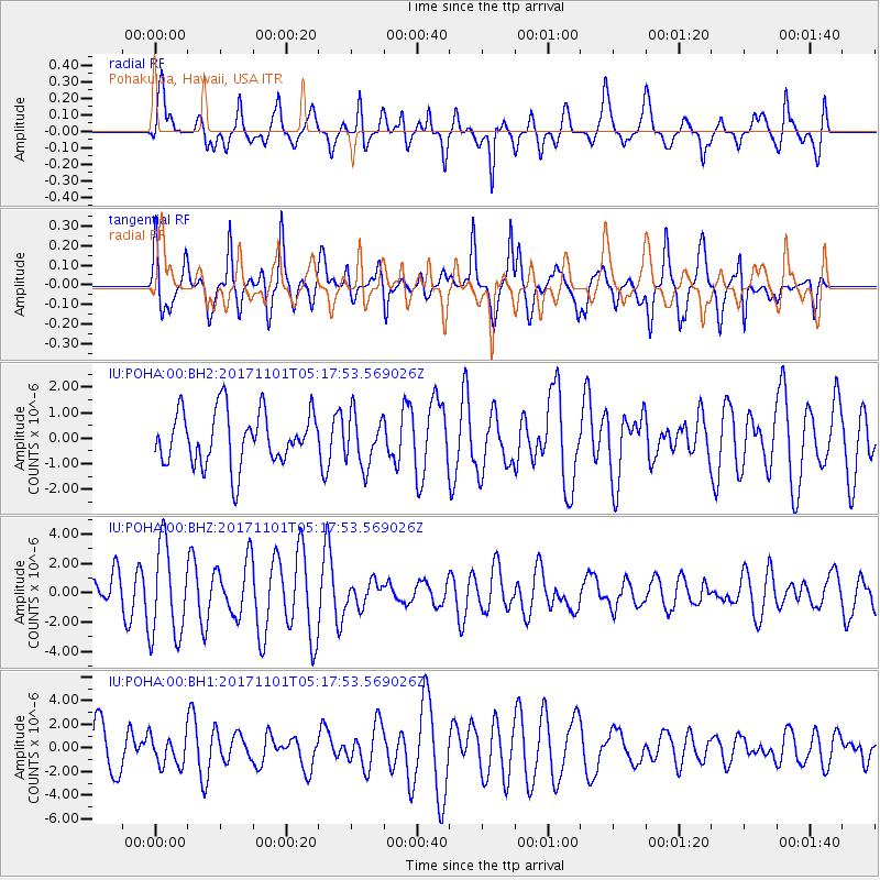
POHA Pohakuloa, Hawaii, USA - Earthquake Result Viewer
*The percent match for this event was below the threshold and hence no stack was calculated.
| Earthquake location: |
Loyalty Islands |
| Earthquake latitude/longitude: |
-21.8/168.9 |
| Earthquake time(UTC): |
2017/11/01 (305) 05:09:00 GMT |
| Earthquake Depth: |
10 km |
| Earthquake Magnitude: |
6.0 Mww |
| Earthquake Catalog/Contributor: |
NEIC PDE/us |
|
| Network: |
IU Global Seismograph Network (GSN - IRIS/USGS) |
| Station: |
POHA Pohakuloa, Hawaii, USA |
| Lat/Lon: |
19.76 N/155.53 W |
| Elevation: |
1990 m |
|
| Distance: |
54.0 deg |
| Az: |
42.617 deg |
| Baz: |
221.923 deg |
| Ray Param: |
$rayparam |
*The percent match for this event was below the threshold and hence was not used in the summary stack. |
|
| Radial Match: |
68.60626 % |
| Radial Bump: |
400 |
| Transverse Match: |
56.72795 % |
| Transverse Bump: |
363 |
| SOD ConfigId: |
2429771 |
| Insert Time: |
2017-11-15 05:10:11.710 +0000 |
| GWidth: |
2.5 |
| Max Bumps: |
400 |
| Tol: |
0.001 |
|
Signal To Noise
| Channel | StoN | STA | LTA |
| IU:POHA:00:BHZ:20171101T05:17:53.569026Z | 2.3778372 | 3.1246263E-6 | 1.3140624E-6 |
| IU:POHA:00:BH1:20171101T05:17:53.569026Z | 0.7090903 | 1.2561823E-6 | 1.7715405E-6 |
| IU:POHA:00:BH2:20171101T05:17:53.569026Z | 0.9616144 | 9.992046E-7 | 1.0390908E-6 |
| Arrivals |
| Ps | |
| PpPs | |
| PsPs/PpSs | |


