You are here: Home > Network List > GE - GEOFON Stations List
> Station MHV GEOFON Station Michnevo, Russia > Earthquake Result Viewer
MHV GEOFON Station Michnevo, Russia - Earthquake Result Viewer
| Earthquake location: |
Sakhalin, Russia |
| Earthquake latitude/longitude: |
52.6/142.8 |
| Earthquake time(UTC): |
1995/05/27 (147) 13:03:55 GMT |
| Earthquake Depth: |
33 km |
| Earthquake Magnitude: |
6.6 MB, 7.6 MS, 7.0 UNKNOWN, 7.0 MW |
| Earthquake Catalog/Contributor: |
WHDF/NEIC |
|
| Network: |
GE GEOFON |
| Station: |
MHV GEOFON Station Michnevo, Russia |
| Lat/Lon: |
54.96 N/37.77 E |
| Elevation: |
150 m |
|
| Distance: |
56.2 deg |
| Az: |
317.941 deg |
| Baz: |
45.158 deg |
| Ray Param: |
0.06420848 |
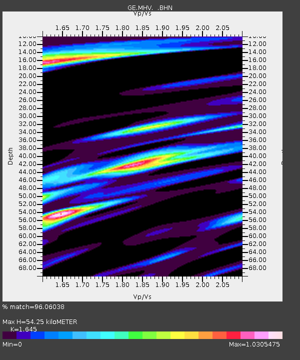
| Estimated Moho Depth: |
54.25 km |
| Estimated Crust Vp/Vs: |
1.64 |
| Assumed Crust Vp: |
6.516 km/s |
| Estimated Crust Vs: |
3.961 km/s |
| Estimated Crust Poisson's Ratio: |
0.21 |
|
| Radial Match: |
96.06038 % |
| Radial Bump: |
375 |
| Transverse Match: |
86.8554 % |
| Transverse Bump: |
400 |
| SOD ConfigId: |
6273 |
| Insert Time: |
2010-03-09 06:30:02.727 +0000 |
| GWidth: |
2.5 |
| Max Bumps: |
400 |
| Tol: |
0.001 |
|

Signal To Noise
| Channel | StoN | STA | LTA |
| GE:MHV: :BHN:19950527T13:13:01.977014Z | 16.819431 | 1.439723E-6 | 8.5598785E-8 |
| GE:MHV: :BHE:19950527T13:13:01.977014Z | 17.042074 | 1.510659E-6 | 8.8642906E-8 |
| GE:MHV: :BHZ:19950527T13:13:01.977014Z | 36.48611 | 3.5362236E-6 | 9.691972E-8 |
| Arrivals |
| Ps | 5.7 SECOND |
| PpPs | 21 SECOND |
| PsPs/PpSs | 26 SECOND |


