You are here: Home > Network List > PS - Pacific21 Stations List
> Station PSI Parapat, Indonesia > Earthquake Result Viewer
PSI Parapat, Indonesia - Earthquake Result Viewer
| Earthquake location: |
East Of North Island, N.Z. |
| Earthquake latitude/longitude: |
-37.8/-179.5 |
| Earthquake time(UTC): |
2021/03/04 (063) 13:27:35 GMT |
| Earthquake Depth: |
10 km |
| Earthquake Magnitude: |
7.3 Mi |
| Earthquake Catalog/Contributor: |
NEIC PDE/at |
|
| Network: |
PS Pacific21 |
| Station: |
PSI Parapat, Indonesia |
| Lat/Lon: |
2.69 N/98.92 E |
| Elevation: |
987 m |
|
| Distance: |
85.0 deg |
| Az: |
277.283 deg |
| Baz: |
128.13 deg |
| Ray Param: |
0.04509513 |
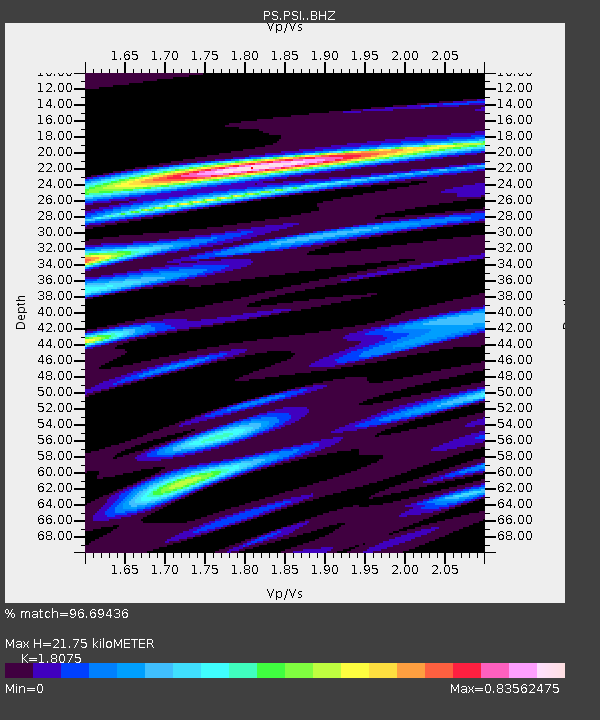
| Estimated Moho Depth: |
21.75 km |
| Estimated Crust Vp/Vs: |
1.81 |
| Assumed Crust Vp: |
6.468 km/s |
| Estimated Crust Vs: |
3.578 km/s |
| Estimated Crust Poisson's Ratio: |
0.28 |
|
| Radial Match: |
96.69436 % |
| Radial Bump: |
396 |
| Transverse Match: |
92.19505 % |
| Transverse Bump: |
400 |
| SOD ConfigId: |
24334971 |
| Insert Time: |
2021-03-29 23:45:06.163 +0000 |
| GWidth: |
2.5 |
| Max Bumps: |
400 |
| Tol: |
0.001 |
|
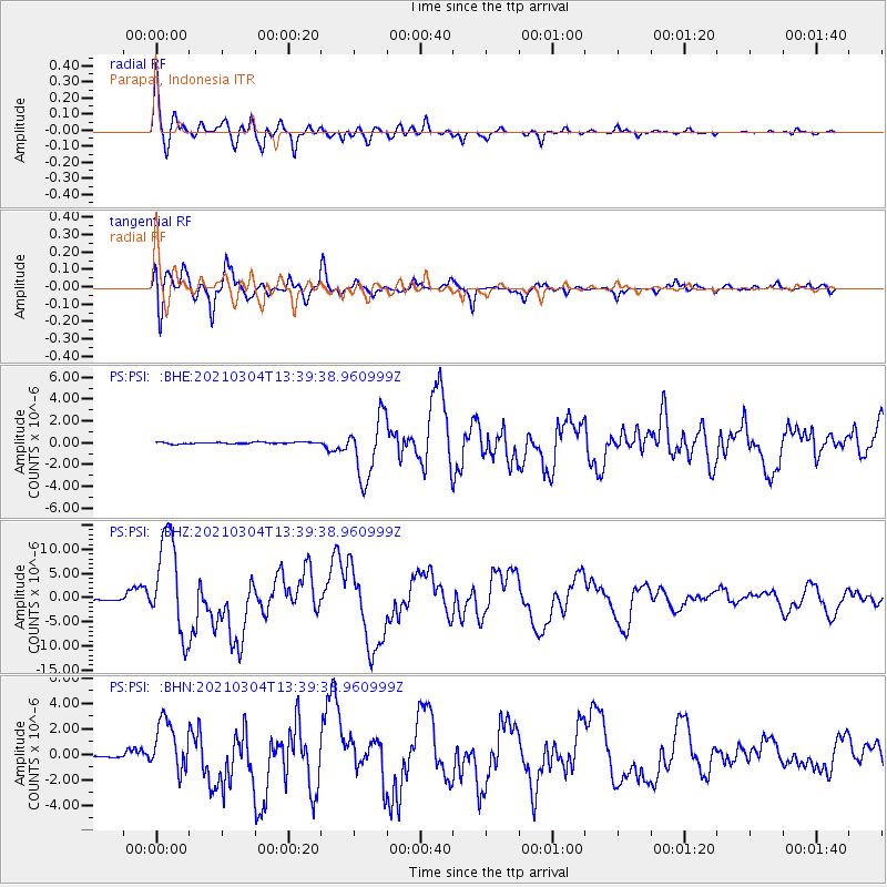
Signal To Noise
| Channel | StoN | STA | LTA |
| PS:PSI: :BHZ:20210304T13:39:38.960999Z | 76.22822 | 1.021981E-5 | 1.3406859E-7 |
| PS:PSI: :BHN:20210304T13:39:38.960999Z | 22.145088 | 2.055485E-6 | 9.281901E-8 |
| PS:PSI: :BHE:20210304T13:39:38.960999Z | 39.092804 | 2.7617948E-6 | 7.064714E-8 |
| Arrivals |
| Ps | 2.8 SECOND |
| PpPs | 9.2 SECOND |
| PsPs/PpSs | 12 SECOND |


