You are here: Home > Network List > GE - GEOFON Stations List
> Station MHV GEOFON Station Michnevo, Russia > Earthquake Result Viewer
MHV GEOFON Station Michnevo, Russia - Earthquake Result Viewer
| Earthquake location: |
Northern Molucca Sea |
| Earthquake latitude/longitude: |
2.6/127.7 |
| Earthquake time(UTC): |
1995/07/26 (207) 23:42:02 GMT |
| Earthquake Depth: |
66 km |
| Earthquake Magnitude: |
5.9 MB, 6.4 UNKNOWN, 6.4 MW |
| Earthquake Catalog/Contributor: |
WHDF/NEIC |
|
| Network: |
GE GEOFON |
| Station: |
MHV GEOFON Station Michnevo, Russia |
| Lat/Lon: |
54.96 N/37.77 E |
| Elevation: |
150 m |
|
| Distance: |
87.9 deg |
| Az: |
324.751 deg |
| Baz: |
88.592 deg |
| Ray Param: |
0.04287857 |
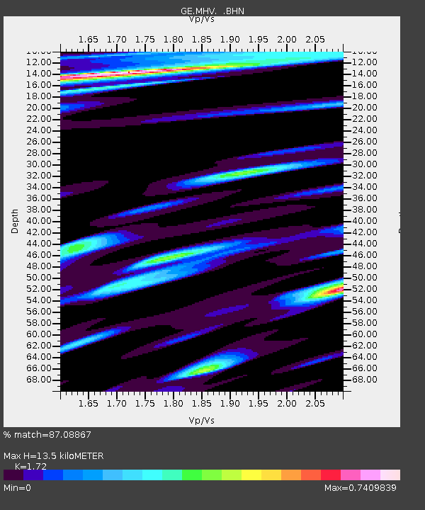
| Estimated Moho Depth: |
13.5 km |
| Estimated Crust Vp/Vs: |
1.72 |
| Assumed Crust Vp: |
6.516 km/s |
| Estimated Crust Vs: |
3.788 km/s |
| Estimated Crust Poisson's Ratio: |
0.24 |
|
| Radial Match: |
87.08867 % |
| Radial Bump: |
400 |
| Transverse Match: |
87.35566 % |
| Transverse Bump: |
400 |
| SOD ConfigId: |
6273 |
| Insert Time: |
2010-03-09 06:30:08.291 +0000 |
| GWidth: |
2.5 |
| Max Bumps: |
400 |
| Tol: |
0.001 |
|

Signal To Noise
| Channel | StoN | STA | LTA |
| GE:MHV: :BHN:19950726T23:54:13.729028Z | 1.0170909 | 1.1854155E-7 | 1.1654961E-7 |
| GE:MHV: :BHE:19950726T23:54:13.729028Z | 1.8092102 | 2.864989E-7 | 1.5835579E-7 |
| GE:MHV: :BHZ:19950726T23:54:13.729028Z | 4.022174 | 5.5499873E-7 | 1.3798477E-7 |
| Arrivals |
| Ps | 1.5 SECOND |
| PpPs | 5.5 SECOND |
| PsPs/PpSs | 7.0 SECOND |


