You are here: Home > Network List > SV - Servicio Nacional de Estudios Territoriales (SNET), El Salvador Stations List
> Station JAYA Z > Earthquake Result Viewer
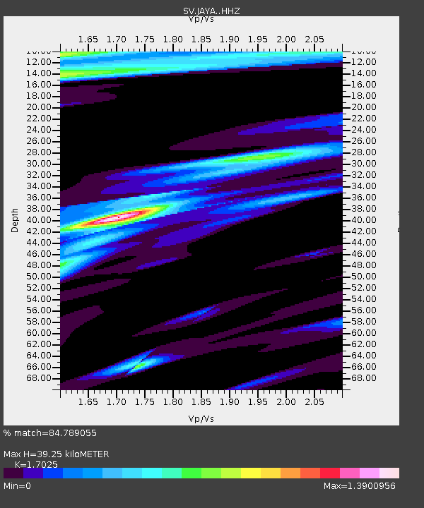
JAYA Z - Earthquake Result Viewer
| Earthquake location: |
East Of North Island, N.Z. |
| Earthquake latitude/longitude: |
-37.8/-179.5 |
| Earthquake time(UTC): |
2021/03/04 (063) 13:27:35 GMT |
| Earthquake Depth: |
10 km |
| Earthquake Magnitude: |
7.3 Mi |
| Earthquake Catalog/Contributor: |
NEIC PDE/at |
|
| Network: |
SV Servicio Nacional de Estudios Territoriales (SNET), El Salvador |
| Station: |
JAYA Z |
| Lat/Lon: |
13.65 N/89.45 W |
| Elevation: |
0.0 m |
|
| Distance: |
98.3 deg |
| Az: |
79.209 deg |
| Baz: |
233.175 deg |
| Ray Param: |
0.039955024 |
| Estimated Moho Depth: |
39.25 km |
| Estimated Crust Vp/Vs: |
1.70 |
| Assumed Crust Vp: |
6.048 km/s |
| Estimated Crust Vs: |
3.552 km/s |
| Estimated Crust Poisson's Ratio: |
0.24 |
|
| Radial Match: |
84.789055 % |
| Radial Bump: |
400 |
| Transverse Match: |
63.45126 % |
| Transverse Bump: |
400 |
| SOD ConfigId: |
24334971 |
| Insert Time: |
2021-03-29 23:45:44.419 +0000 |
| GWidth: |
2.5 |
| Max Bumps: |
400 |
| Tol: |
0.001 |
|

Signal To Noise
| Channel | StoN | STA | LTA |
| SV:JAYA: :HHZ:20210304T13:40:40.669983Z | 0.66797394 | 4.6698904E-7 | 6.991127E-7 |
| SV:JAYA: :HHN:20210304T13:40:40.669983Z | 1.4358568 | 8.764306E-7 | 6.103886E-7 |
| SV:JAYA: :HHE:20210304T13:40:40.669983Z | 1.3191735 | 1.3303334E-6 | 1.0084597E-6 |
| Arrivals |
| Ps | 4.6 SECOND |
| PpPs | 17 SECOND |
| PsPs/PpSs | 22 SECOND |


