You are here: Home > Network List > CC - Cascade Chain Volcano Monitoring Stations List
> Station PR01 Puyallup River 01 > Earthquake Result Viewer
PR01 Puyallup River 01 - Earthquake Result Viewer
| Earthquake location: |
Off East Coast Of Kamchatka |
| Earthquake latitude/longitude: |
54.7/163.2 |
| Earthquake time(UTC): |
2021/03/16 (075) 18:38:22 GMT |
| Earthquake Depth: |
22 km |
| Earthquake Magnitude: |
6.6 mww |
| Earthquake Catalog/Contributor: |
NEIC PDE/us |
|
| Network: |
CC Cascade Chain Volcano Monitoring |
| Station: |
PR01 Puyallup River 01 |
| Lat/Lon: |
46.91 N/122.04 W |
| Elevation: |
648 m |
|
| Distance: |
45.8 deg |
| Az: |
67.371 deg |
| Baz: |
308.609 deg |
| Ray Param: |
0.07103121 |
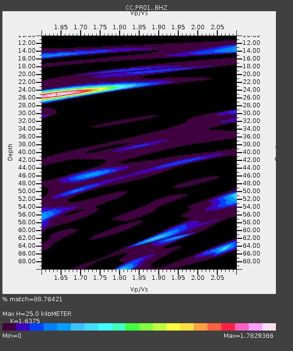
| Estimated Moho Depth: |
25.0 km |
| Estimated Crust Vp/Vs: |
1.64 |
| Assumed Crust Vp: |
6.566 km/s |
| Estimated Crust Vs: |
4.01 km/s |
| Estimated Crust Poisson's Ratio: |
0.20 |
|
| Radial Match: |
88.76421 % |
| Radial Bump: |
400 |
| Transverse Match: |
83.69325 % |
| Transverse Bump: |
400 |
| SOD ConfigId: |
24334971 |
| Insert Time: |
2021-03-30 18:43:53.387 +0000 |
| GWidth: |
2.5 |
| Max Bumps: |
400 |
| Tol: |
0.001 |
|

Signal To Noise
| Channel | StoN | STA | LTA |
| CC:PR01: :BHZ:20210316T18:46:11.880008Z | 1.8257574 | 3.036578E-7 | 1.6631881E-7 |
| CC:PR01: :BHN:20210316T18:46:11.880008Z | 2.2547123 | 4.083348E-7 | 1.8110285E-7 |
| CC:PR01: :BHE:20210316T18:46:11.880008Z | 0.5511069 | 1.4919326E-7 | 2.7071562E-7 |
| Arrivals |
| Ps | 2.6 SECOND |
| PpPs | 9.3 SECOND |
| PsPs/PpSs | 12 SECOND |


