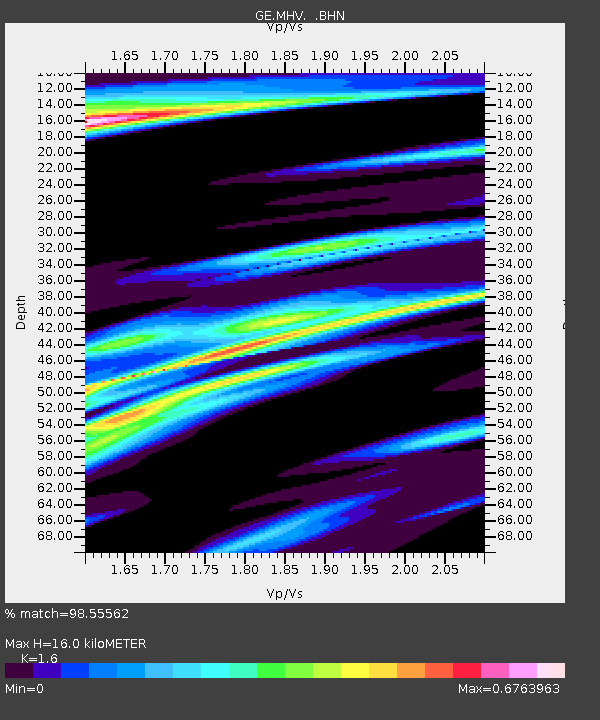
MHV GEOFON Station Michnevo, Russia - Earthquake Result Viewer

Earthquake location: Andreanof Islands, Aleutian Is.
Earthquake latitude/longitude: 51.5/-176.8
Earthquake time(UTC): 1996/06/10 (162) 15:24:56 GMT
Earthquake Depth: 26 km
Earthquake Magnitude: 5.9 MB, 7.1 MS, 7.2 UNKNOWN, 6.9 MS
Earthquake Catalog/Contributor: WHDF/NEIC
Network: GE GEOFON
Station: MHV GEOFON Station Michnevo, Russia
Lat/Lon: 54.96 N/37.77 E
Elevation: 150 m
Distance: 70.1 deg
Az: 339.608 deg
Baz: 22.199 deg
Ray Param: 0.055183098
Estimated Moho Depth: 16.0 km
Estimated Crust Vp/Vs: 1.60
Assumed Crust Vp: 6.516 km/s
Estimated Crust Vs: 4.073 km/s
Estimated Crust Poisson's Ratio: 0.18
Radial Match: 98.55562 %
Radial Bump: 281
Transverse Match: 86.988075 %
Transverse Bump: 400
SOD ConfigId: 6273
Insert Time: 2010-03-09 06:30:29.055 +0000
GWidth: 2.5
Max Bumps: 400
Tol: 0.001

Signal To Noise

ChannelStoNSTALTA
GE:MHV: :BHN:19960610T15:35:34.666016Z1.15735451.9783944E-71.7094109E-7
GE:MHV: :BHE:19960610T15:35:34.666016Z0.822527171.9873796E-72.4161872E-7
GE:MHV: :BHZ:19960610T15:35:34.666016Z3.42339754.5086608E-71.3170136E-7
Arrivals
Ps1.5 SECOND
PpPs6.1 SECOND
PsPs/PpSs7.7 SECOND