You are here: Home > Network List > US - United States National Seismic Network Stations List
> Station HAWA Hanford, Washington, USA > Earthquake Result Viewer
HAWA Hanford, Washington, USA - Earthquake Result Viewer
*The percent match for this event was below the threshold and hence no stack was calculated.
| Earthquake location: |
Loyalty Islands |
| Earthquake latitude/longitude: |
-21.8/168.9 |
| Earthquake time(UTC): |
2017/11/01 (305) 05:09:00 GMT |
| Earthquake Depth: |
10 km |
| Earthquake Magnitude: |
6.0 Mww |
| Earthquake Catalog/Contributor: |
NEIC PDE/us |
|
| Network: |
US United States National Seismic Network |
| Station: |
HAWA Hanford, Washington, USA |
| Lat/Lon: |
46.39 N/119.53 W |
| Elevation: |
364 m |
|
| Distance: |
93.6 deg |
| Az: |
41.137 deg |
| Baz: |
242.05 deg |
| Ray Param: |
$rayparam |
*The percent match for this event was below the threshold and hence was not used in the summary stack. |
|
| Radial Match: |
67.283714 % |
| Radial Bump: |
400 |
| Transverse Match: |
68.112625 % |
| Transverse Bump: |
400 |
| SOD ConfigId: |
2429771 |
| Insert Time: |
2017-11-15 05:10:43.623 +0000 |
| GWidth: |
2.5 |
| Max Bumps: |
400 |
| Tol: |
0.001 |
|
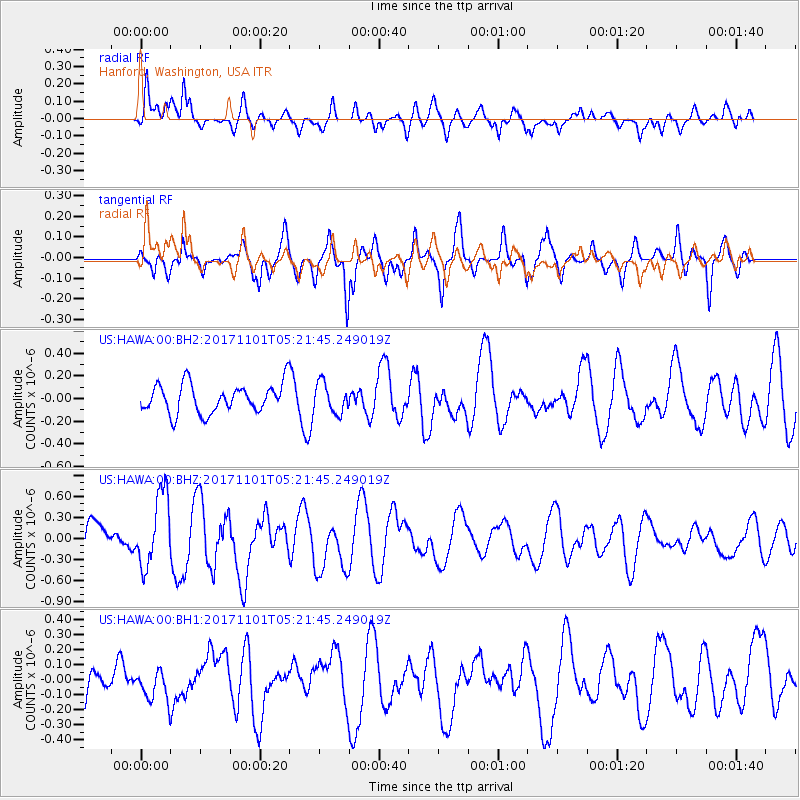
Signal To Noise
| Channel | StoN | STA | LTA |
| US:HAWA:00:BHZ:20171101T05:21:45.249019Z | 2.0363533 | 5.2466197E-7 | 2.576478E-7 |
| US:HAWA:00:BH1:20171101T05:21:45.249019Z | 0.4988439 | 9.377054E-8 | 1.8797571E-7 |
| US:HAWA:00:BH2:20171101T05:21:45.249019Z | 1.0242677 | 1.312275E-7 | 1.2811836E-7 |
| Arrivals |
| Ps | |
| PpPs | |
| PsPs/PpSs | |


