You are here: Home > Network List > CC - Cascade Chain Volcano Monitoring Stations List
> Station OPCH Ohanapecosh Administrative Area > Earthquake Result Viewer
OPCH Ohanapecosh Administrative Area - Earthquake Result Viewer
| Earthquake location: |
Off East Coast Of Kamchatka |
| Earthquake latitude/longitude: |
54.7/163.2 |
| Earthquake time(UTC): |
2021/03/16 (075) 18:38:22 GMT |
| Earthquake Depth: |
22 km |
| Earthquake Magnitude: |
6.6 mww |
| Earthquake Catalog/Contributor: |
NEIC PDE/us |
|
| Network: |
CC Cascade Chain Volcano Monitoring |
| Station: |
OPCH Ohanapecosh Administrative Area |
| Lat/Lon: |
46.73 N/121.57 W |
| Elevation: |
593 m |
|
| Distance: |
46.1 deg |
| Az: |
67.286 deg |
| Baz: |
308.889 deg |
| Ray Param: |
0.070815794 |
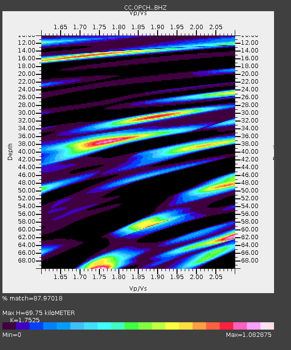
| Estimated Moho Depth: |
69.75 km |
| Estimated Crust Vp/Vs: |
1.75 |
| Assumed Crust Vp: |
6.597 km/s |
| Estimated Crust Vs: |
3.765 km/s |
| Estimated Crust Poisson's Ratio: |
0.26 |
|
| Radial Match: |
87.97018 % |
| Radial Bump: |
400 |
| Transverse Match: |
63.906376 % |
| Transverse Bump: |
400 |
| SOD ConfigId: |
24334971 |
| Insert Time: |
2021-03-30 18:44:22.829 +0000 |
| GWidth: |
2.5 |
| Max Bumps: |
400 |
| Tol: |
0.001 |
|

Signal To Noise
| Channel | StoN | STA | LTA |
| CC:OPCH: :BHZ:20210316T18:46:14.739993Z | 1.7617098 | 2.2990567E-7 | 1.3050143E-7 |
| CC:OPCH: :BHN:20210316T18:46:14.739993Z | 4.007966 | 1.0911413E-6 | 2.7224314E-7 |
| CC:OPCH: :BHE:20210316T18:46:14.739993Z | 1.3774003 | 3.83189E-7 | 2.7819726E-7 |
| Arrivals |
| Ps | 8.5 SECOND |
| PpPs | 27 SECOND |
| PsPs/PpSs | 36 SECOND |


