You are here: Home > Network List > CN - Canadian National Seismograph Network Stations List
> Station SNB Saturna Island, BC, CA > Earthquake Result Viewer
SNB Saturna Island, BC, CA - Earthquake Result Viewer
| Earthquake location: |
Off East Coast Of Kamchatka |
| Earthquake latitude/longitude: |
54.7/163.2 |
| Earthquake time(UTC): |
2021/03/16 (075) 18:38:22 GMT |
| Earthquake Depth: |
22 km |
| Earthquake Magnitude: |
6.6 mww |
| Earthquake Catalog/Contributor: |
NEIC PDE/us |
|
| Network: |
CN Canadian National Seismograph Network |
| Station: |
SNB Saturna Island, BC, CA |
| Lat/Lon: |
48.78 N/123.17 W |
| Elevation: |
402 m |
|
| Distance: |
44.0 deg |
| Az: |
65.941 deg |
| Baz: |
306.757 deg |
| Ray Param: |
0.07214759 |
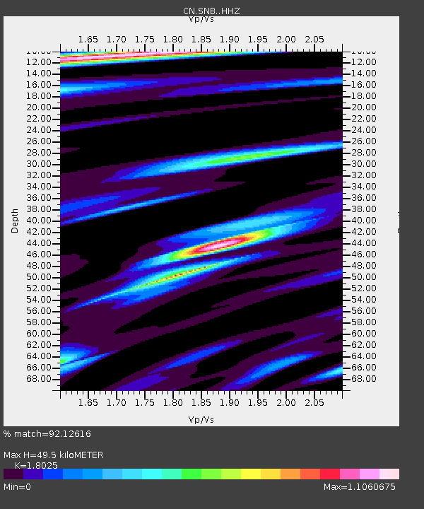
| Estimated Moho Depth: |
49.5 km |
| Estimated Crust Vp/Vs: |
1.80 |
| Assumed Crust Vp: |
6.566 km/s |
| Estimated Crust Vs: |
3.643 km/s |
| Estimated Crust Poisson's Ratio: |
0.28 |
|
| Radial Match: |
92.12616 % |
| Radial Bump: |
400 |
| Transverse Match: |
87.10626 % |
| Transverse Bump: |
400 |
| SOD ConfigId: |
24334971 |
| Insert Time: |
2021-03-30 18:47:11.594 +0000 |
| GWidth: |
2.5 |
| Max Bumps: |
400 |
| Tol: |
0.001 |
|

Signal To Noise
| Channel | StoN | STA | LTA |
| CN:SNB: :HHZ:20210316T18:45:58.010012Z | 1.1686211 | 3.2663036E-7 | 2.7950065E-7 |
| CN:SNB: :HHN:20210316T18:45:58.010012Z | 0.7593639 | 2.2113859E-7 | 2.9121557E-7 |
| CN:SNB: :HHE:20210316T18:45:58.010012Z | 0.6903795 | 3.626068E-7 | 5.2522824E-7 |
| Arrivals |
| Ps | 6.5 SECOND |
| PpPs | 20 SECOND |
| PsPs/PpSs | 26 SECOND |


