You are here: Home > Network List > G - GEOSCOPE Stations List
> Station SANVU Espiritu Santo, Vanuatu > Earthquake Result Viewer
SANVU Espiritu Santo, Vanuatu - Earthquake Result Viewer
| Earthquake location: |
Off East Coast Of Kamchatka |
| Earthquake latitude/longitude: |
54.7/163.2 |
| Earthquake time(UTC): |
2021/03/16 (075) 18:38:22 GMT |
| Earthquake Depth: |
22 km |
| Earthquake Magnitude: |
6.6 mww |
| Earthquake Catalog/Contributor: |
NEIC PDE/us |
|
| Network: |
G GEOSCOPE |
| Station: |
SANVU Espiritu Santo, Vanuatu |
| Lat/Lon: |
15.45 S/167.20 E |
| Elevation: |
56 m |
|
| Distance: |
70.0 deg |
| Az: |
175.898 deg |
| Baz: |
357.533 deg |
| Ray Param: |
0.055293377 |
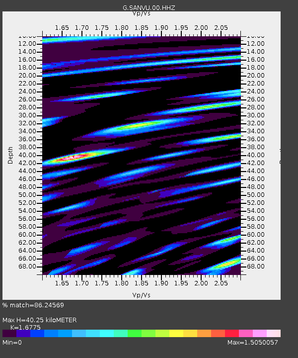
| Estimated Moho Depth: |
40.25 km |
| Estimated Crust Vp/Vs: |
1.68 |
| Assumed Crust Vp: |
4.802 km/s |
| Estimated Crust Vs: |
2.863 km/s |
| Estimated Crust Poisson's Ratio: |
0.22 |
|
| Radial Match: |
86.24569 % |
| Radial Bump: |
400 |
| Transverse Match: |
79.62734 % |
| Transverse Bump: |
400 |
| SOD ConfigId: |
24334971 |
| Insert Time: |
2021-03-30 18:48:46.517 +0000 |
| GWidth: |
2.5 |
| Max Bumps: |
400 |
| Tol: |
0.001 |
|

Signal To Noise
| Channel | StoN | STA | LTA |
| G:SANVU:00:HHZ:20210316T18:49:01.230014Z | 7.069009 | 1.216105E-6 | 1.7203331E-7 |
| G:SANVU:00:HHN:20210316T18:49:01.230014Z | 1.835183 | 6.0836476E-7 | 3.3150087E-7 |
| G:SANVU:00:HHE:20210316T18:49:01.230014Z | 1.3136061 | 2.7189853E-7 | 2.0698633E-7 |
| Arrivals |
| Ps | 5.8 SECOND |
| PpPs | 22 SECOND |
| PsPs/PpSs | 28 SECOND |


