You are here: Home > Network List > IU - Global Seismograph Network (GSN - IRIS/USGS) Stations List
> Station RSSD Black Hills, South Dakota, USA > Earthquake Result Viewer
RSSD Black Hills, South Dakota, USA - Earthquake Result Viewer
| Earthquake location: |
Off East Coast Of Kamchatka |
| Earthquake latitude/longitude: |
54.7/163.2 |
| Earthquake time(UTC): |
2021/03/16 (075) 18:38:22 GMT |
| Earthquake Depth: |
22 km |
| Earthquake Magnitude: |
6.6 mww |
| Earthquake Catalog/Contributor: |
NEIC PDE/us |
|
| Network: |
IU Global Seismograph Network (GSN - IRIS/USGS) |
| Station: |
RSSD Black Hills, South Dakota, USA |
| Lat/Lon: |
44.12 N/104.04 W |
| Elevation: |
2090 m |
|
| Distance: |
57.0 deg |
| Az: |
59.08 deg |
| Baz: |
316.261 deg |
| Ray Param: |
0.0637484 |
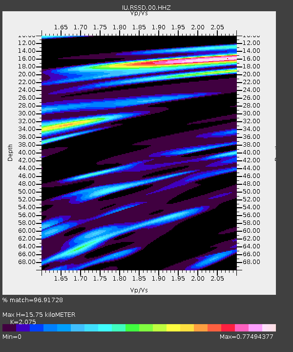
| Estimated Moho Depth: |
15.75 km |
| Estimated Crust Vp/Vs: |
2.08 |
| Assumed Crust Vp: |
6.242 km/s |
| Estimated Crust Vs: |
3.008 km/s |
| Estimated Crust Poisson's Ratio: |
0.35 |
|
| Radial Match: |
96.91728 % |
| Radial Bump: |
400 |
| Transverse Match: |
89.019165 % |
| Transverse Bump: |
400 |
| SOD ConfigId: |
24334971 |
| Insert Time: |
2021-03-30 18:51:33.955 +0000 |
| GWidth: |
2.5 |
| Max Bumps: |
400 |
| Tol: |
0.001 |
|
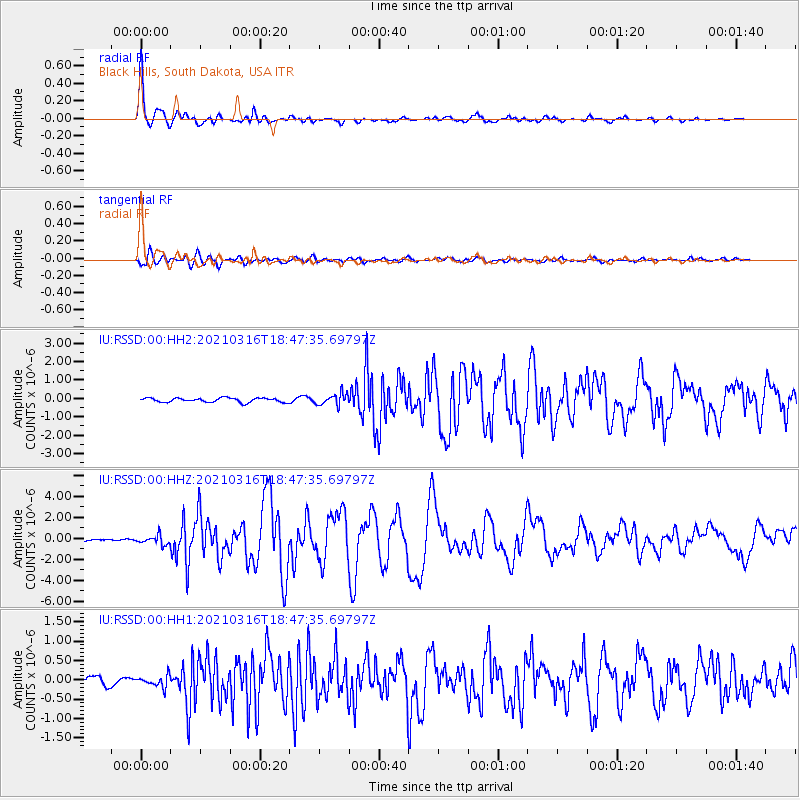
Signal To Noise
| Channel | StoN | STA | LTA |
| IU:RSSD:00:HHZ:20210316T18:47:35.69797Z | 3.8025527 | 4.3835533E-7 | 1.1527923E-7 |
| IU:RSSD:00:HH1:20210316T18:47:35.69797Z | 1.5525132 | 1.4680103E-7 | 9.455702E-8 |
| IU:RSSD:00:HH2:20210316T18:47:35.69797Z | 2.7093067 | 3.099978E-7 | 1.14419606E-7 |
| Arrivals |
| Ps | 2.8 SECOND |
| PpPs | 7.5 SECOND |
| PsPs/PpSs | 10 SECOND |


