You are here: Home > Network List > N4 - Central and EAstern US Network Stations List
> Station K22A Casper, WY, USA > Earthquake Result Viewer
K22A Casper, WY, USA - Earthquake Result Viewer
| Earthquake location: |
Off East Coast Of Kamchatka |
| Earthquake latitude/longitude: |
54.7/163.2 |
| Earthquake time(UTC): |
2021/03/16 (075) 18:38:22 GMT |
| Earthquake Depth: |
22 km |
| Earthquake Magnitude: |
6.6 mww |
| Earthquake Catalog/Contributor: |
NEIC PDE/us |
|
| Network: |
N4 Central and EAstern US Network |
| Station: |
K22A Casper, WY, USA |
| Lat/Lon: |
42.65 N/106.52 W |
| Elevation: |
1686 m |
|
| Distance: |
56.8 deg |
| Az: |
61.857 deg |
| Baz: |
316.075 deg |
| Ray Param: |
0.06388268 |
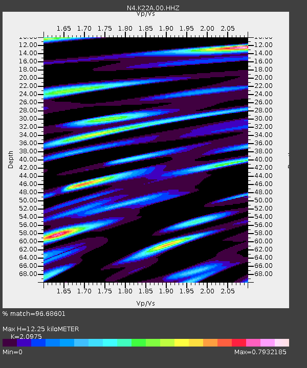
| Estimated Moho Depth: |
12.25 km |
| Estimated Crust Vp/Vs: |
2.10 |
| Assumed Crust Vp: |
6.178 km/s |
| Estimated Crust Vs: |
2.946 km/s |
| Estimated Crust Poisson's Ratio: |
0.35 |
|
| Radial Match: |
96.68601 % |
| Radial Bump: |
400 |
| Transverse Match: |
86.57994 % |
| Transverse Bump: |
400 |
| SOD ConfigId: |
24334971 |
| Insert Time: |
2021-03-30 18:53:57.250 +0000 |
| GWidth: |
2.5 |
| Max Bumps: |
400 |
| Tol: |
0.001 |
|

Signal To Noise
| Channel | StoN | STA | LTA |
| N4:K22A:00:HHZ:20210316T18:47:34.308993Z | 2.3389542 | 3.6587366E-7 | 1.5642618E-7 |
| N4:K22A:00:HH1:20210316T18:47:34.308993Z | 1.2990128 | 1.5432423E-7 | 1.18801154E-7 |
| N4:K22A:00:HH2:20210316T18:47:34.308993Z | 1.1605479 | 1.5785905E-7 | 1.3602114E-7 |
| Arrivals |
| Ps | 2.3 SECOND |
| PpPs | 5.9 SECOND |
| PsPs/PpSs | 8.2 SECOND |


