You are here: Home > Network List > N4 - Central and EAstern US Network Stations List
> Station MDND Maddock, ND, USA > Earthquake Result Viewer
MDND Maddock, ND, USA - Earthquake Result Viewer
| Earthquake location: |
Off East Coast Of Kamchatka |
| Earthquake latitude/longitude: |
54.7/163.2 |
| Earthquake time(UTC): |
2021/03/16 (075) 18:38:22 GMT |
| Earthquake Depth: |
22 km |
| Earthquake Magnitude: |
6.6 mww |
| Earthquake Catalog/Contributor: |
NEIC PDE/us |
|
| Network: |
N4 Central and EAstern US Network |
| Station: |
MDND Maddock, ND, USA |
| Lat/Lon: |
47.85 N/99.60 W |
| Elevation: |
479 m |
|
| Distance: |
56.4 deg |
| Az: |
53.326 deg |
| Baz: |
316.281 deg |
| Ray Param: |
0.064121 |
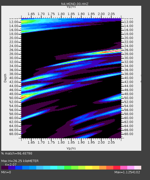
| Estimated Moho Depth: |
26.25 km |
| Estimated Crust Vp/Vs: |
2.07 |
| Assumed Crust Vp: |
6.53 km/s |
| Estimated Crust Vs: |
3.155 km/s |
| Estimated Crust Poisson's Ratio: |
0.35 |
|
| Radial Match: |
96.48798 % |
| Radial Bump: |
336 |
| Transverse Match: |
85.66047 % |
| Transverse Bump: |
400 |
| SOD ConfigId: |
24334971 |
| Insert Time: |
2021-03-30 18:54:13.417 +0000 |
| GWidth: |
2.5 |
| Max Bumps: |
400 |
| Tol: |
0.001 |
|

Signal To Noise
| Channel | StoN | STA | LTA |
| N4:MDND:00:HHZ:20210316T18:47:31.759005Z | 6.5106106 | 1.255931E-6 | 1.9290526E-7 |
| N4:MDND:00:HH1:20210316T18:47:31.759005Z | 1.595771 | 5.7646366E-7 | 3.6124464E-7 |
| N4:MDND:00:HH2:20210316T18:47:31.759005Z | 0.9649927 | 4.0612792E-7 | 4.208611E-7 |
| Arrivals |
| Ps | 4.5 SECOND |
| PpPs | 12 SECOND |
| PsPs/PpSs | 16 SECOND |


