You are here: Home > Network List > N4 - Central and EAstern US Network Stations List
> Station N41A Harden Midland Farm, Stronghurst, IL, USA > Earthquake Result Viewer
N41A Harden Midland Farm, Stronghurst, IL, USA - Earthquake Result Viewer
| Earthquake location: |
Off East Coast Of Kamchatka |
| Earthquake latitude/longitude: |
54.7/163.2 |
| Earthquake time(UTC): |
2021/03/16 (075) 18:38:22 GMT |
| Earthquake Depth: |
22 km |
| Earthquake Magnitude: |
6.6 mww |
| Earthquake Catalog/Contributor: |
NEIC PDE/us |
|
| Network: |
N4 Central and EAstern US Network |
| Station: |
N41A Harden Midland Farm, Stronghurst, IL, USA |
| Lat/Lon: |
40.71 N/90.86 W |
| Elevation: |
226 m |
|
| Distance: |
65.9 deg |
| Az: |
53.189 deg |
| Baz: |
322.319 deg |
| Ray Param: |
0.057925913 |
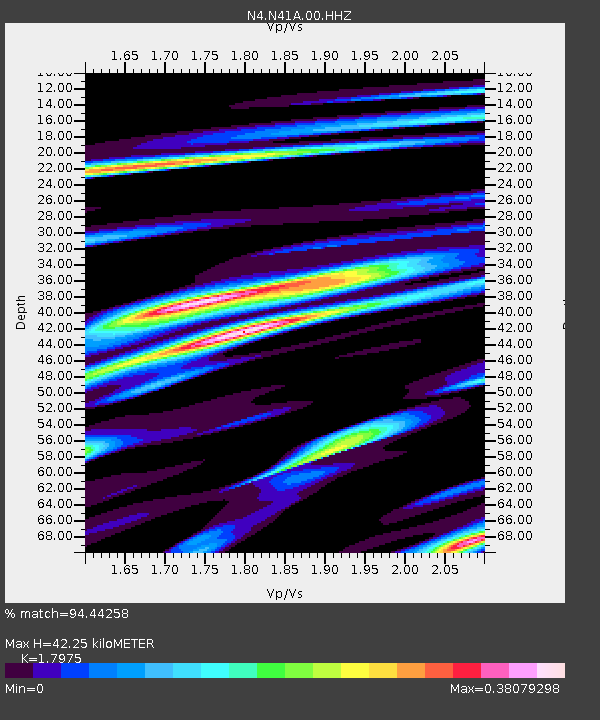
| Estimated Moho Depth: |
42.25 km |
| Estimated Crust Vp/Vs: |
1.80 |
| Assumed Crust Vp: |
6.498 km/s |
| Estimated Crust Vs: |
3.615 km/s |
| Estimated Crust Poisson's Ratio: |
0.28 |
|
| Radial Match: |
94.44258 % |
| Radial Bump: |
251 |
| Transverse Match: |
62.039097 % |
| Transverse Bump: |
372 |
| SOD ConfigId: |
24334971 |
| Insert Time: |
2021-03-30 18:54:18.002 +0000 |
| GWidth: |
2.5 |
| Max Bumps: |
400 |
| Tol: |
0.001 |
|

Signal To Noise
| Channel | StoN | STA | LTA |
| N4:N41A:00:HHZ:20210316T18:48:35.980014Z | 2.4598243 | 1.0943895E-6 | 4.4490554E-7 |
| N4:N41A:00:HH1:20210316T18:48:35.980014Z | 1.1129955 | 3.6054493E-7 | 3.2394104E-7 |
| N4:N41A:00:HH2:20210316T18:48:35.980014Z | 1.0081342 | 3.0714497E-7 | 3.0466674E-7 |
| Arrivals |
| Ps | 5.4 SECOND |
| PpPs | 17 SECOND |
| PsPs/PpSs | 23 SECOND |


